You are here: Home > Network List > IU - Global Seismograph Network (GSN - IRIS/USGS) Stations List
> Station HNR Honiara, Solomon Islands > Earthquake Result Viewer
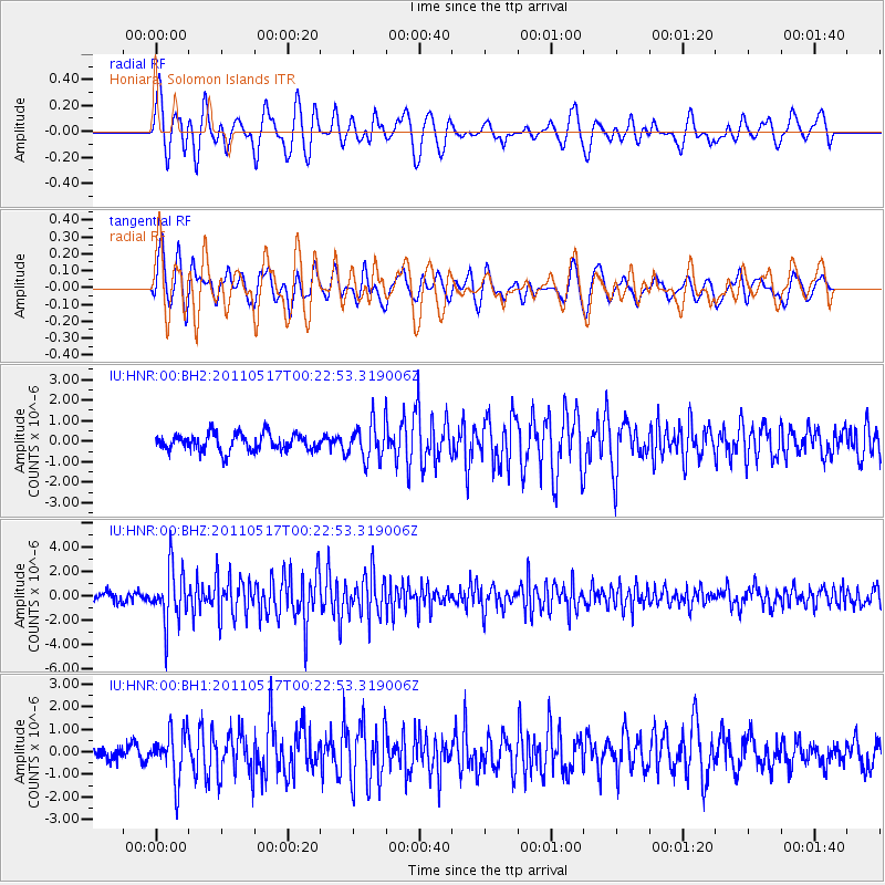
HNR Honiara, Solomon Islands - Earthquake Result Viewer
*The percent match for this event was below the threshold and hence no stack was calculated.
| Earthquake location: |
South Of Java, Indonesia |
| Earthquake latitude/longitude: |
-9.2/112.6 |
| Earthquake time(UTC): |
2011/05/17 (137) 00:14:57 GMT |
| Earthquake Depth: |
28 km |
| Earthquake Magnitude: |
5.7 MB, 5.2 MS, 5.6 MW, 5.6 MW |
| Earthquake Catalog/Contributor: |
WHDF/NEIC |
|
| Network: |
IU Global Seismograph Network (GSN - IRIS/USGS) |
| Station: |
HNR Honiara, Solomon Islands |
| Lat/Lon: |
9.44 S/159.95 E |
| Elevation: |
100 m |
|
| Distance: |
46.7 deg |
| Az: |
94.307 deg |
| Baz: |
266.234 deg |
| Ray Param: |
$rayparam |
*The percent match for this event was below the threshold and hence was not used in the summary stack. |
|
| Radial Match: |
73.67792 % |
| Radial Bump: |
400 |
| Transverse Match: |
71.87261 % |
| Transverse Bump: |
400 |
| SOD ConfigId: |
558545 |
| Insert Time: |
2013-09-18 18:27:04.602 +0000 |
| GWidth: |
2.5 |
| Max Bumps: |
400 |
| Tol: |
0.001 |
|
Signal To Noise
| Channel | StoN | STA | LTA |
| IU:HNR:00:BHZ:20110517T00:22:53.319006Z | 5.198606 | 2.286076E-6 | 4.397479E-7 |
| IU:HNR:00:BH1:20110517T00:22:53.319006Z | 3.0600066 | 1.0375923E-6 | 3.390817E-7 |
| IU:HNR:00:BH2:20110517T00:22:53.319006Z | 2.1450622 | 8.8400384E-7 | 4.1211104E-7 |
| Arrivals |
| Ps | |
| PpPs | |
| PsPs/PpSs | |


