You are here: Home > Network List > IU - Global Seismograph Network (GSN - IRIS/USGS) Stations List
> Station MAKZ Makanchi, Kazakhstan > Earthquake Result Viewer
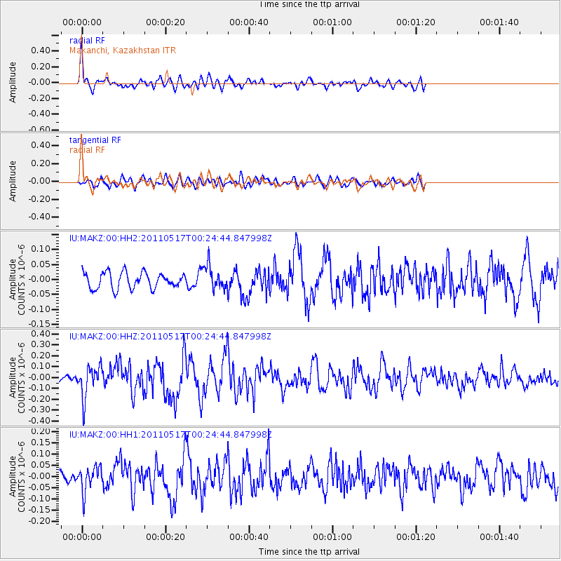
MAKZ Makanchi, Kazakhstan - Earthquake Result Viewer
*The percent match for this event was below the threshold and hence no stack was calculated.
| Earthquake location: |
South Of Java, Indonesia |
| Earthquake latitude/longitude: |
-9.2/112.6 |
| Earthquake time(UTC): |
2011/05/17 (137) 00:14:57 GMT |
| Earthquake Depth: |
28 km |
| Earthquake Magnitude: |
5.7 MB, 5.2 MS, 5.6 MW, 5.6 MW |
| Earthquake Catalog/Contributor: |
WHDF/NEIC |
|
| Network: |
IU Global Seismograph Network (GSN - IRIS/USGS) |
| Station: |
MAKZ Makanchi, Kazakhstan |
| Lat/Lon: |
46.81 N/81.98 E |
| Elevation: |
600 m |
|
| Distance: |
62.1 deg |
| Az: |
336.684 deg |
| Baz: |
145.326 deg |
| Ray Param: |
$rayparam |
*The percent match for this event was below the threshold and hence was not used in the summary stack. |
|
| Radial Match: |
77.896065 % |
| Radial Bump: |
400 |
| Transverse Match: |
66.72098 % |
| Transverse Bump: |
400 |
| SOD ConfigId: |
558545 |
| Insert Time: |
2013-09-18 18:27:17.687 +0000 |
| GWidth: |
2.5 |
| Max Bumps: |
400 |
| Tol: |
0.001 |
|
Signal To Noise
| Channel | StoN | STA | LTA |
| IU:MAKZ:00:HHZ:20110517T00:24:44.847998Z | 3.399105 | 1.4604257E-7 | 4.2965002E-8 |
| IU:MAKZ:00:HH1:20110517T00:24:44.847998Z | 1.9133617 | 5.592936E-8 | 2.923094E-8 |
| IU:MAKZ:00:HH2:20110517T00:24:44.847998Z | 1.4667683 | 3.942181E-8 | 2.6876645E-8 |
| Arrivals |
| Ps | |
| PpPs | |
| PsPs/PpSs | |


