You are here: Home > Network List > II - Global Seismograph Network (GSN - IRIS/IDA) Stations List
> Station WRAB Tennant Creek, NT, Australia > Earthquake Result Viewer
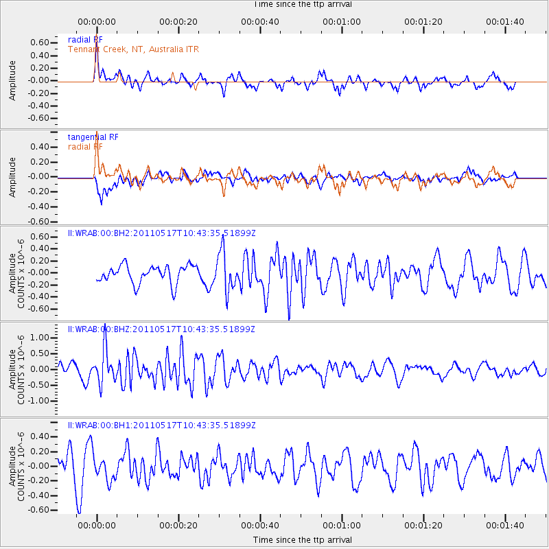
WRAB Tennant Creek, NT, Australia - Earthquake Result Viewer
*The percent match for this event was below the threshold and hence no stack was calculated.
| Earthquake location: |
Tonga Islands |
| Earthquake latitude/longitude: |
-15.6/-175.2 |
| Earthquake time(UTC): |
2011/05/17 (137) 10:35:26 GMT |
| Earthquake Depth: |
10 km |
| Earthquake Magnitude: |
5.7 MW, 5.6 MW |
| Earthquake Catalog/Contributor: |
NEIC PDE/NEIC PDE-M |
|
| Network: |
II Global Seismograph Network (GSN - IRIS/IDA) |
| Station: |
WRAB Tennant Creek, NT, Australia |
| Lat/Lon: |
19.93 S/134.36 E |
| Elevation: |
366 m |
|
| Distance: |
48.1 deg |
| Az: |
257.116 deg |
| Baz: |
93.399 deg |
| Ray Param: |
$rayparam |
*The percent match for this event was below the threshold and hence was not used in the summary stack. |
|
| Radial Match: |
64.37884 % |
| Radial Bump: |
397 |
| Transverse Match: |
64.71562 % |
| Transverse Bump: |
400 |
| SOD ConfigId: |
558545 |
| Insert Time: |
2013-09-18 18:28:23.262 +0000 |
| GWidth: |
2.5 |
| Max Bumps: |
400 |
| Tol: |
0.001 |
|
Signal To Noise
| Channel | StoN | STA | LTA |
| II:WRAB:00:BHZ:20110517T10:43:35.51899Z | 3.2069411 | 5.439507E-7 | 1.6961668E-7 |
| II:WRAB:00:BH1:20110517T10:43:35.51899Z | 0.8429127 | 1.5560728E-7 | 1.8460666E-7 |
| II:WRAB:00:BH2:20110517T10:43:35.51899Z | 2.1788166 | 3.2270214E-7 | 1.4810891E-7 |
| Arrivals |
| Ps | |
| PpPs | |
| PsPs/PpSs | |


