You are here: Home > Network List > IU - Global Seismograph Network (GSN - IRIS/USGS) Stations List
> Station PMG Port Moresby, New Guinea > Earthquake Result Viewer
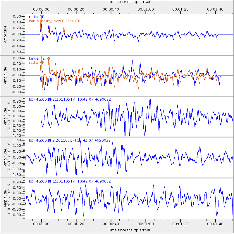
PMG Port Moresby, New Guinea - Earthquake Result Viewer
*The percent match for this event was below the threshold and hence no stack was calculated.
| Earthquake location: |
Tonga Islands |
| Earthquake latitude/longitude: |
-15.6/-175.2 |
| Earthquake time(UTC): |
2011/05/17 (137) 10:35:26 GMT |
| Earthquake Depth: |
10 km |
| Earthquake Magnitude: |
5.7 MW, 5.6 MW |
| Earthquake Catalog/Contributor: |
NEIC PDE/NEIC PDE-M |
|
| Network: |
IU Global Seismograph Network (GSN - IRIS/USGS) |
| Station: |
PMG Port Moresby, New Guinea |
| Lat/Lon: |
9.40 S/147.16 E |
| Elevation: |
90 m |
|
| Distance: |
37.2 deg |
| Az: |
275.034 deg |
| Baz: |
103.442 deg |
| Ray Param: |
$rayparam |
*The percent match for this event was below the threshold and hence was not used in the summary stack. |
|
| Radial Match: |
66.69963 % |
| Radial Bump: |
400 |
| Transverse Match: |
56.074715 % |
| Transverse Bump: |
400 |
| SOD ConfigId: |
558545 |
| Insert Time: |
2013-09-18 18:28:51.974 +0000 |
| GWidth: |
2.5 |
| Max Bumps: |
400 |
| Tol: |
0.001 |
|
Signal To Noise
| Channel | StoN | STA | LTA |
| IU:PMG:00:BHZ:20110517T10:42:07.469003Z | 2.1772256 | 5.2331364E-7 | 2.4035805E-7 |
| IU:PMG:00:BH1:20110517T10:42:07.469003Z | 0.8117882 | 2.8189422E-7 | 3.4725096E-7 |
| IU:PMG:00:BH2:20110517T10:42:07.469003Z | 1.0663025 | 3.3396557E-7 | 3.1319965E-7 |
| Arrivals |
| Ps | |
| PpPs | |
| PsPs/PpSs | |


