You are here: Home > Network List > US - United States National Seismic Network Stations List
> Station HAWA Hanford, Washington, USA > Earthquake Result Viewer
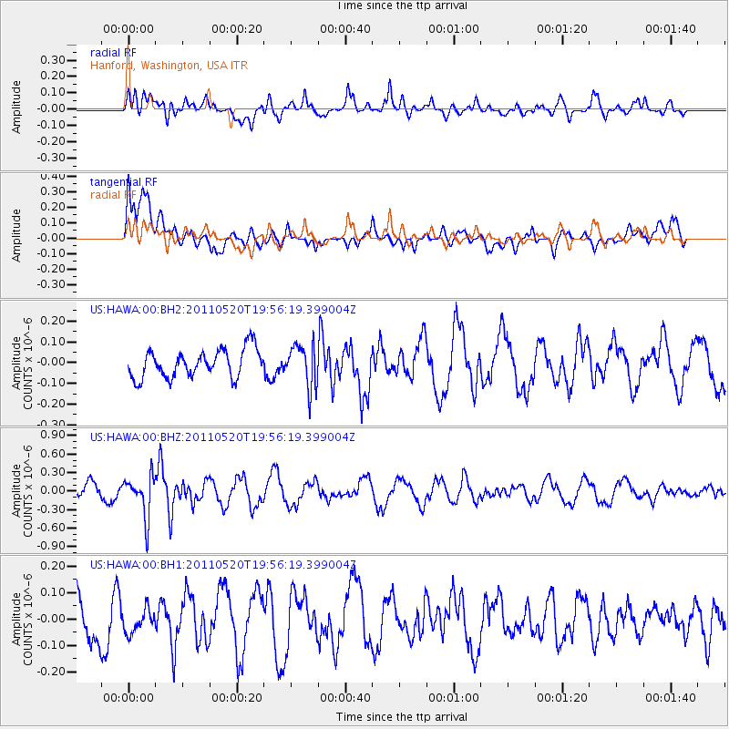
HAWA Hanford, Washington, USA - Earthquake Result Viewer
*The percent match for this event was below the threshold and hence no stack was calculated.
| Earthquake location: |
Eastern New Guinea Reg., P.N.G. |
| Earthquake latitude/longitude: |
-7.2/146.9 |
| Earthquake time(UTC): |
2011/05/20 (140) 19:43:16 GMT |
| Earthquake Depth: |
7.0 km |
| Earthquake Magnitude: |
6.2 MB, 5.5 MS, 5.7 MW, 5.7 MW |
| Earthquake Catalog/Contributor: |
WHDF/NEIC |
|
| Network: |
US United States National Seismic Network |
| Station: |
HAWA Hanford, Washington, USA |
| Lat/Lon: |
46.39 N/119.53 W |
| Elevation: |
364 m |
|
| Distance: |
97.6 deg |
| Az: |
44.182 deg |
| Baz: |
267.593 deg |
| Ray Param: |
$rayparam |
*The percent match for this event was below the threshold and hence was not used in the summary stack. |
|
| Radial Match: |
60.241142 % |
| Radial Bump: |
400 |
| Transverse Match: |
54.196224 % |
| Transverse Bump: |
400 |
| SOD ConfigId: |
558545 |
| Insert Time: |
2013-09-18 18:43:56.721 +0000 |
| GWidth: |
2.5 |
| Max Bumps: |
400 |
| Tol: |
0.001 |
|
Signal To Noise
| Channel | StoN | STA | LTA |
| US:HAWA:00:BHZ:20110520T19:56:19.399004Z | 3.000552 | 3.3399434E-7 | 1.1131096E-7 |
| US:HAWA:00:BH1:20110520T19:56:19.399004Z | 0.36789623 | 4.6958245E-8 | 1.2763992E-7 |
| US:HAWA:00:BH2:20110520T19:56:19.399004Z | 1.5225974 | 1.030216E-7 | 6.7661745E-8 |
| Arrivals |
| Ps | |
| PpPs | |
| PsPs/PpSs | |


