You are here: Home > Network List > II - Global Seismograph Network (GSN - IRIS/IDA) Stations List
> Station WRAB Tennant Creek, NT, Australia > Earthquake Result Viewer
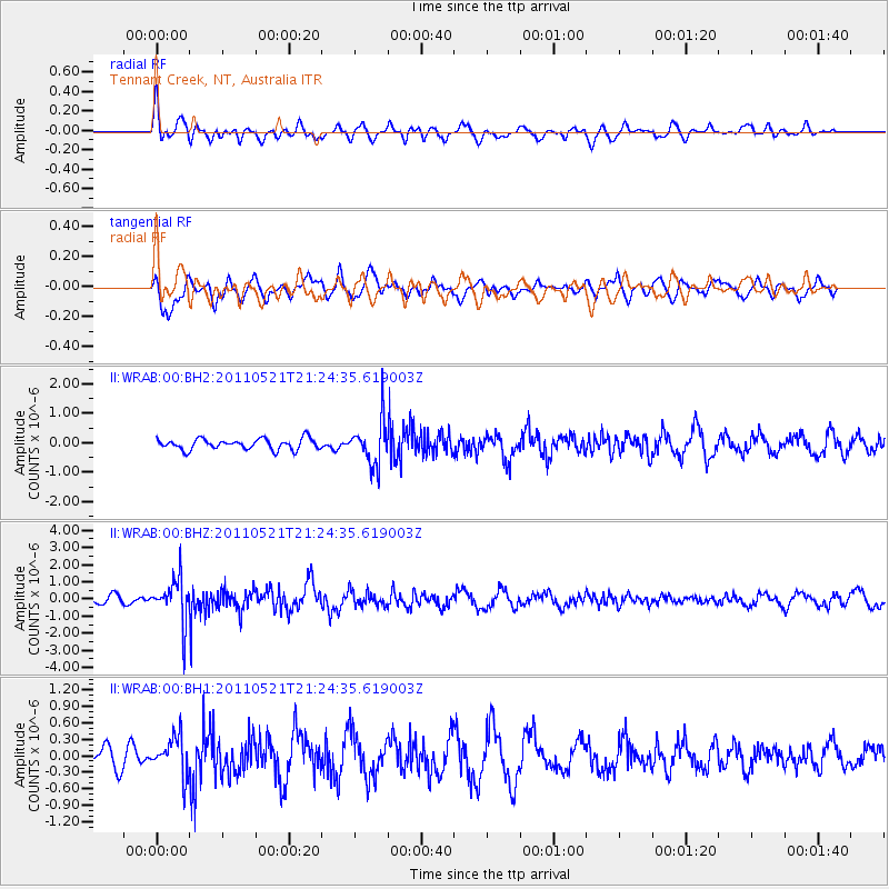
WRAB Tennant Creek, NT, Australia - Earthquake Result Viewer
*The percent match for this event was below the threshold and hence no stack was calculated.
| Earthquake location: |
Kermadec Islands, New Zealand |
| Earthquake latitude/longitude: |
-30.8/-178.2 |
| Earthquake time(UTC): |
2011/05/21 (141) 21:17:02 GMT |
| Earthquake Depth: |
34 km |
| Earthquake Magnitude: |
5.5 MB, 5.4 MS, 5.8 MW, 5.8 MW |
| Earthquake Catalog/Contributor: |
WHDF/NEIC |
|
| Network: |
II Global Seismograph Network (GSN - IRIS/IDA) |
| Station: |
WRAB Tennant Creek, NT, Australia |
| Lat/Lon: |
19.93 S/134.36 E |
| Elevation: |
366 m |
|
| Distance: |
44.0 deg |
| Az: |
272.699 deg |
| Baz: |
114.024 deg |
| Ray Param: |
$rayparam |
*The percent match for this event was below the threshold and hence was not used in the summary stack. |
|
| Radial Match: |
53.783657 % |
| Radial Bump: |
400 |
| Transverse Match: |
69.00737 % |
| Transverse Bump: |
400 |
| SOD ConfigId: |
558545 |
| Insert Time: |
2013-09-18 18:46:01.582 +0000 |
| GWidth: |
2.5 |
| Max Bumps: |
400 |
| Tol: |
0.001 |
|
Signal To Noise
| Channel | StoN | STA | LTA |
| II:WRAB:00:BHZ:20110521T21:24:35.619003Z | 4.6146035 | 1.2243942E-6 | 2.6533033E-7 |
| II:WRAB:00:BH1:20110521T21:24:35.619003Z | 1.6938655 | 3.3866965E-7 | 1.9993892E-7 |
| II:WRAB:00:BH2:20110521T21:24:35.619003Z | 3.9952273 | 7.323096E-7 | 1.8329611E-7 |
| Arrivals |
| Ps | |
| PpPs | |
| PsPs/PpSs | |


