You are here: Home > Network List > II - Global Seismograph Network (GSN - IRIS/IDA) Stations List
> Station WRAB Tennant Creek, NT, Australia > Earthquake Result Viewer
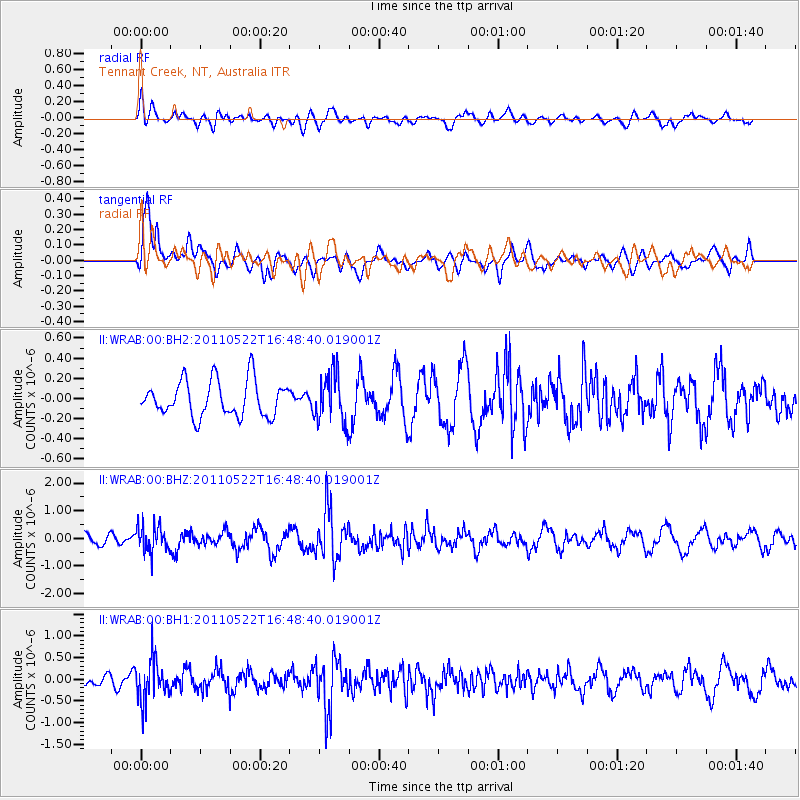
WRAB Tennant Creek, NT, Australia - Earthquake Result Viewer
*The percent match for this event was below the threshold and hence no stack was calculated.
| Earthquake location: |
Mindoro, Philippines |
| Earthquake latitude/longitude: |
13.6/120.8 |
| Earthquake time(UTC): |
2011/05/22 (142) 16:42:24 GMT |
| Earthquake Depth: |
149 km |
| Earthquake Magnitude: |
5.5 MB, 5.7 MW, 5.7 MW |
| Earthquake Catalog/Contributor: |
WHDF/NEIC |
|
| Network: |
II Global Seismograph Network (GSN - IRIS/IDA) |
| Station: |
WRAB Tennant Creek, NT, Australia |
| Lat/Lon: |
19.93 S/134.36 E |
| Elevation: |
366 m |
|
| Distance: |
35.9 deg |
| Az: |
157.829 deg |
| Baz: |
337.044 deg |
| Ray Param: |
$rayparam |
*The percent match for this event was below the threshold and hence was not used in the summary stack. |
|
| Radial Match: |
49.48012 % |
| Radial Bump: |
400 |
| Transverse Match: |
65.92987 % |
| Transverse Bump: |
400 |
| SOD ConfigId: |
558545 |
| Insert Time: |
2013-09-18 18:53:30.783 +0000 |
| GWidth: |
2.5 |
| Max Bumps: |
400 |
| Tol: |
0.001 |
|
Signal To Noise
| Channel | StoN | STA | LTA |
| II:WRAB:00:BHZ:20110522T16:48:40.019001Z | 2.4112227 | 4.7494723E-7 | 1.9697362E-7 |
| II:WRAB:00:BH1:20110522T16:48:40.019001Z | 2.6404355 | 4.653379E-7 | 1.7623529E-7 |
| II:WRAB:00:BH2:20110522T16:48:40.019001Z | 1.3671837 | 2.4066603E-7 | 1.760305E-7 |
| Arrivals |
| Ps | |
| PpPs | |
| PsPs/PpSs | |


