You are here: Home > Network List > NX - Nanometrics Research Network Stations List
> Station STN31 Seismic station 26 > Earthquake Result Viewer
STN31 Seismic station 26 - Earthquake Result Viewer
| Earthquake location: |
Easter Island Region |
| Earthquake latitude/longitude: |
-26.5/-114.6 |
| Earthquake time(UTC): |
2014/09/03 (246) 20:34:00 GMT |
| Earthquake Depth: |
10 km |
| Earthquake Magnitude: |
5.9 MWB |
| Earthquake Catalog/Contributor: |
NEIC PDE/NEIC COMCAT |
|
| Network: |
NX Nanometrics Research Network |
| Station: |
STN31 Seismic station 26 |
| Lat/Lon: |
35.76 N/97.44 W |
| Elevation: |
329 m |
|
| Distance: |
64.1 deg |
| Az: |
15.5 deg |
| Baz: |
197.116 deg |
| Ray Param: |
0.05916741 |
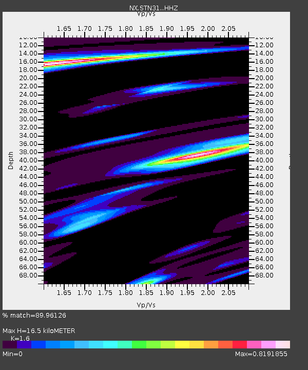
| Estimated Moho Depth: |
16.5 km |
| Estimated Crust Vp/Vs: |
1.60 |
| Assumed Crust Vp: |
6.426 km/s |
| Estimated Crust Vs: |
4.016 km/s |
| Estimated Crust Poisson's Ratio: |
0.18 |
|
| Radial Match: |
89.96126 % |
| Radial Bump: |
330 |
| Transverse Match: |
70.921 % |
| Transverse Bump: |
326 |
| SOD ConfigId: |
3390531 |
| Insert Time: |
2019-04-13 20:09:52.842 +0000 |
| GWidth: |
2.5 |
| Max Bumps: |
400 |
| Tol: |
0.001 |
|

Signal To Noise
| Channel | StoN | STA | LTA |
| NX:STN31: :HHZ:20140903T20:44:03.56001Z | 9.495103 | 1.189446E-6 | 1.2526942E-7 |
| NX:STN31: :HH1:20140903T20:44:03.56001Z | 3.5727975 | 4.3750305E-7 | 1.2245391E-7 |
| NX:STN31: :HH2:20140903T20:44:03.56001Z | 3.0543108 | 3.2861797E-7 | 1.0759153E-7 |
| Arrivals |
| Ps | 1.6 SECOND |
| PpPs | 6.4 SECOND |
| PsPs/PpSs | 8.0 SECOND |


