You are here: Home > Network List > US - United States National Seismic Network Stations List
> Station CBKS Cedar Bluff, Kansas, USA > Earthquake Result Viewer
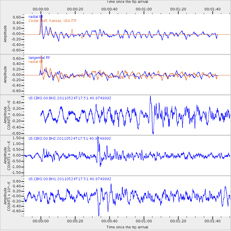
CBKS Cedar Bluff, Kansas, USA - Earthquake Result Viewer
*The percent match for this event was below the threshold and hence no stack was calculated.
| Earthquake location: |
Andreanof Islands, Aleutian Is. |
| Earthquake latitude/longitude: |
52.6/-173.3 |
| Earthquake time(UTC): |
2011/05/24 (144) 17:43:24 GMT |
| Earthquake Depth: |
138 km |
| Earthquake Magnitude: |
5.6 MB, 5.5 MW, 5.5 MW |
| Earthquake Catalog/Contributor: |
WHDF/NEIC |
|
| Network: |
US United States National Seismic Network |
| Station: |
CBKS Cedar Bluff, Kansas, USA |
| Lat/Lon: |
38.81 N/99.74 W |
| Elevation: |
677 m |
|
| Distance: |
51.0 deg |
| Az: |
74.684 deg |
| Baz: |
311.141 deg |
| Ray Param: |
$rayparam |
*The percent match for this event was below the threshold and hence was not used in the summary stack. |
|
| Radial Match: |
74.620834 % |
| Radial Bump: |
400 |
| Transverse Match: |
48.913982 % |
| Transverse Bump: |
400 |
| SOD ConfigId: |
558545 |
| Insert Time: |
2013-09-18 18:59:21.080 +0000 |
| GWidth: |
2.5 |
| Max Bumps: |
400 |
| Tol: |
0.001 |
|
Signal To Noise
| Channel | StoN | STA | LTA |
| US:CBKS:00:BHZ:20110524T17:51:40.974999Z | 3.2565844 | 2.6150326E-7 | 8.0299856E-8 |
| US:CBKS:00:BH1:20110524T17:51:40.974999Z | 1.2485194 | 1.5757537E-7 | 1.262098E-7 |
| US:CBKS:00:BH2:20110524T17:51:40.974999Z | 1.3025765 | 1.71257E-7 | 1.3147557E-7 |
| Arrivals |
| Ps | |
| PpPs | |
| PsPs/PpSs | |


