You are here: Home > Network List > IU - Global Seismograph Network (GSN - IRIS/USGS) Stations List
> Station HNR Honiara, Solomon Islands > Earthquake Result Viewer
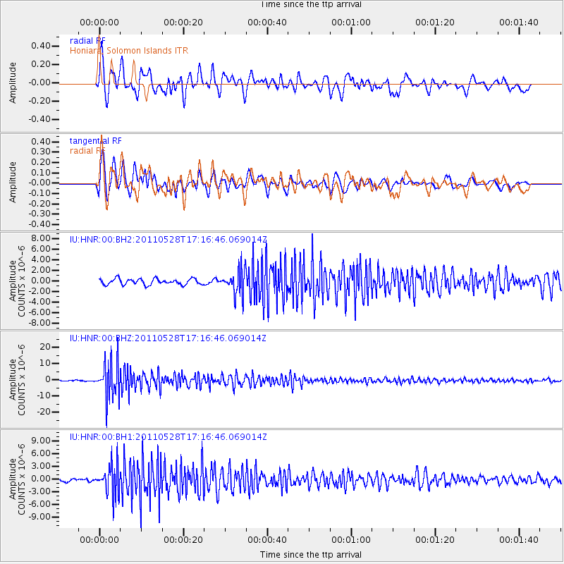
HNR Honiara, Solomon Islands - Earthquake Result Viewer
*The percent match for this event was below the threshold and hence no stack was calculated.
| Earthquake location: |
Southern Sumatra, Indonesia |
| Earthquake latitude/longitude: |
-5.7/103.5 |
| Earthquake time(UTC): |
2011/05/28 (148) 17:07:41 GMT |
| Earthquake Depth: |
32 km |
| Earthquake Magnitude: |
5.7 MW, 5.5 MW, 5.5 MS, 6.1 MB |
| Earthquake Catalog/Contributor: |
NEIC PDE/NEIC PDE-M |
|
| Network: |
IU Global Seismograph Network (GSN - IRIS/USGS) |
| Station: |
HNR Honiara, Solomon Islands |
| Lat/Lon: |
9.44 S/159.95 E |
| Elevation: |
100 m |
|
| Distance: |
56.0 deg |
| Az: |
97.503 deg |
| Baz: |
269.46 deg |
| Ray Param: |
$rayparam |
*The percent match for this event was below the threshold and hence was not used in the summary stack. |
|
| Radial Match: |
78.961655 % |
| Radial Bump: |
400 |
| Transverse Match: |
83.66195 % |
| Transverse Bump: |
400 |
| SOD ConfigId: |
558545 |
| Insert Time: |
2013-09-18 19:01:30.427 +0000 |
| GWidth: |
2.5 |
| Max Bumps: |
400 |
| Tol: |
0.001 |
|
Signal To Noise
| Channel | StoN | STA | LTA |
| IU:HNR:00:BHZ:20110528T17:16:46.069014Z | 44.68356 | 1.0852214E-5 | 2.4286814E-7 |
| IU:HNR:00:BH1:20110528T17:16:46.069014Z | 8.26797 | 3.5227195E-6 | 4.2606823E-7 |
| IU:HNR:00:BH2:20110528T17:16:46.069014Z | 4.2416053 | 2.351585E-6 | 5.544092E-7 |
| Arrivals |
| Ps | |
| PpPs | |
| PsPs/PpSs | |


