You are here: Home > Network List > US - United States National Seismic Network Stations List
> Station WMOK Wichita Mountains, Oklahoma, USA > Earthquake Result Viewer
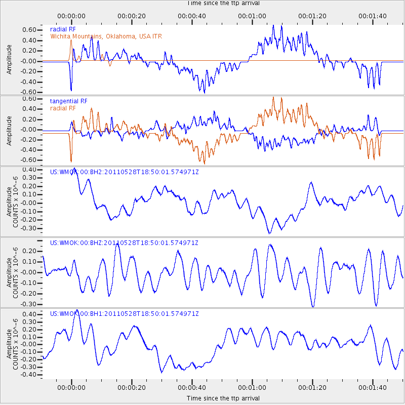
WMOK Wichita Mountains, Oklahoma, USA - Earthquake Result Viewer
*The percent match for this event was below the threshold and hence no stack was calculated.
| Earthquake location: |
Kermadec Islands Region |
| Earthquake latitude/longitude: |
-27.3/-178.5 |
| Earthquake time(UTC): |
2011/05/28 (148) 18:37:34 GMT |
| Earthquake Depth: |
307 km |
| Earthquake Magnitude: |
5.5 MW |
| Earthquake Catalog/Contributor: |
NEIC PDE/NEIC PDE-M |
|
| Network: |
US United States National Seismic Network |
| Station: |
WMOK Wichita Mountains, Oklahoma, USA |
| Lat/Lon: |
34.74 N/98.78 W |
| Elevation: |
486 m |
|
| Distance: |
97.3 deg |
| Az: |
54.795 deg |
| Baz: |
242.031 deg |
| Ray Param: |
$rayparam |
*The percent match for this event was below the threshold and hence was not used in the summary stack. |
|
| Radial Match: |
56.180595 % |
| Radial Bump: |
400 |
| Transverse Match: |
55.94189 % |
| Transverse Bump: |
400 |
| SOD ConfigId: |
558545 |
| Insert Time: |
2013-09-18 19:05:20.888 +0000 |
| GWidth: |
2.5 |
| Max Bumps: |
400 |
| Tol: |
0.001 |
|
Signal To Noise
| Channel | StoN | STA | LTA |
| US:WMOK:00:BHZ:20110528T18:50:01.574971Z | 1.0988253 | 1.0225431E-7 | 9.3057835E-8 |
| US:WMOK:00:BH1:20110528T18:50:01.574971Z | 1.4823899 | 2.4736826E-7 | 1.6687126E-7 |
| US:WMOK:00:BH2:20110528T18:50:01.574971Z | 0.6842523 | 1.1232749E-7 | 1.6416092E-7 |
| Arrivals |
| Ps | |
| PpPs | |
| PsPs/PpSs | |


