You are here: Home > Network List > US - United States National Seismic Network Stations List
> Station GLMI Grayling, Michigan, USA > Earthquake Result Viewer
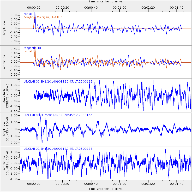
GLMI Grayling, Michigan, USA - Earthquake Result Viewer
*The percent match for this event was below the threshold and hence no stack was calculated.
| Earthquake location: |
Easter Island Region |
| Earthquake latitude/longitude: |
-26.5/-114.6 |
| Earthquake time(UTC): |
2014/09/03 (246) 20:34:00 GMT |
| Earthquake Depth: |
10 km |
| Earthquake Magnitude: |
5.9 MWB |
| Earthquake Catalog/Contributor: |
NEIC PDE/NEIC COMCAT |
|
| Network: |
US United States National Seismic Network |
| Station: |
GLMI Grayling, Michigan, USA |
| Lat/Lon: |
44.82 N/84.62 W |
| Elevation: |
387 m |
|
| Distance: |
76.1 deg |
| Az: |
21.507 deg |
| Baz: |
207.482 deg |
| Ray Param: |
$rayparam |
*The percent match for this event was below the threshold and hence was not used in the summary stack. |
|
| Radial Match: |
79.92274 % |
| Radial Bump: |
400 |
| Transverse Match: |
64.39445 % |
| Transverse Bump: |
400 |
| SOD ConfigId: |
3390531 |
| Insert Time: |
2019-04-13 20:11:47.603 +0000 |
| GWidth: |
2.5 |
| Max Bumps: |
400 |
| Tol: |
0.001 |
|
Signal To Noise
| Channel | StoN | STA | LTA |
| US:GLMI:00:BHZ:20140903T20:45:17.250012Z | 7.959097 | 1.0753716E-6 | 1.3511227E-7 |
| US:GLMI:00:BH1:20140903T20:45:17.250012Z | 1.5271091 | 5.401822E-7 | 3.537286E-7 |
| US:GLMI:00:BH2:20140903T20:45:17.250012Z | 1.583014 | 4.2039858E-7 | 2.6556845E-7 |
| Arrivals |
| Ps | |
| PpPs | |
| PsPs/PpSs | |


