You are here: Home > Network List > US - United States National Seismic Network Stations List
> Station DGMT Dagmar, Montana, USA > Earthquake Result Viewer
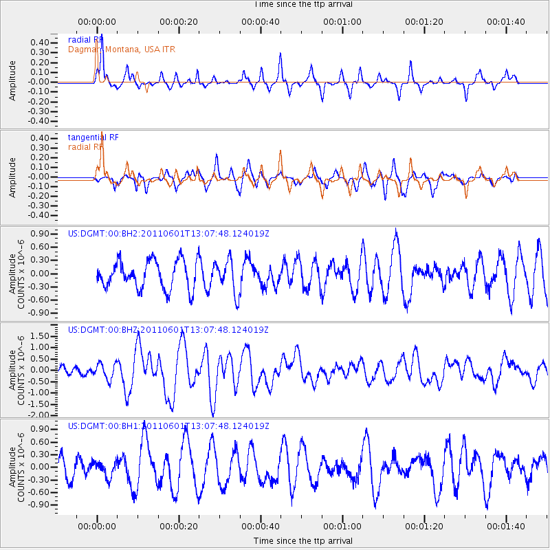
DGMT Dagmar, Montana, USA - Earthquake Result Viewer
*The percent match for this event was below the threshold and hence no stack was calculated.
| Earthquake location: |
Near Coast Of Central Chile |
| Earthquake latitude/longitude: |
-37.6/-73.7 |
| Earthquake time(UTC): |
2011/06/01 (152) 12:55:22 GMT |
| Earthquake Depth: |
21 km |
| Earthquake Magnitude: |
5.6 MB, 6.2 MS, 6.3 MW, 6.3 MW |
| Earthquake Catalog/Contributor: |
WHDF/NEIC |
|
| Network: |
US United States National Seismic Network |
| Station: |
DGMT Dagmar, Montana, USA |
| Lat/Lon: |
48.47 N/104.20 W |
| Elevation: |
0.0 m |
|
| Distance: |
89.9 deg |
| Az: |
340.256 deg |
| Baz: |
156.216 deg |
| Ray Param: |
$rayparam |
*The percent match for this event was below the threshold and hence was not used in the summary stack. |
|
| Radial Match: |
75.35746 % |
| Radial Bump: |
305 |
| Transverse Match: |
61.962368 % |
| Transverse Bump: |
400 |
| SOD ConfigId: |
558545 |
| Insert Time: |
2013-09-18 19:10:41.759 +0000 |
| GWidth: |
2.5 |
| Max Bumps: |
400 |
| Tol: |
0.001 |
|
Signal To Noise
| Channel | StoN | STA | LTA |
| US:DGMT:00:BHZ:20110601T13:07:48.124019Z | 2.4759548 | 3.4725173E-7 | 1.4024963E-7 |
| US:DGMT:00:BH1:20110601T13:07:48.124019Z | 0.65767574 | 1.843392E-7 | 2.8028887E-7 |
| US:DGMT:00:BH2:20110601T13:07:48.124019Z | 1.2306467 | 3.8941988E-7 | 3.1643515E-7 |
| Arrivals |
| Ps | |
| PpPs | |
| PsPs/PpSs | |


