You are here: Home > Network List > US - United States National Seismic Network Stations List
> Station WRAK Wrangell Island, Southeastern Alaska, Alaska, USA > Earthquake Result Viewer
WRAK Wrangell Island, Southeastern Alaska, Alaska, USA - Earthquake Result Viewer
| Earthquake location: |
Off East Coast Of Honshu, Japan |
| Earthquake latitude/longitude: |
37.3/143.9 |
| Earthquake time(UTC): |
2011/06/03 (154) 00:05:00 GMT |
| Earthquake Depth: |
14 km |
| Earthquake Magnitude: |
6.2 MW, 5.9 MS, 6.1 MW, 6.4 MB |
| Earthquake Catalog/Contributor: |
NEIC PDE/NEIC PDE-M |
|
| Network: |
US United States National Seismic Network |
| Station: |
WRAK Wrangell Island, Southeastern Alaska, Alaska, USA |
| Lat/Lon: |
56.42 N/132.35 W |
| Elevation: |
81 m |
|
| Distance: |
56.6 deg |
| Az: |
41.399 deg |
| Baz: |
288.349 deg |
| Ray Param: |
0.06399497 |
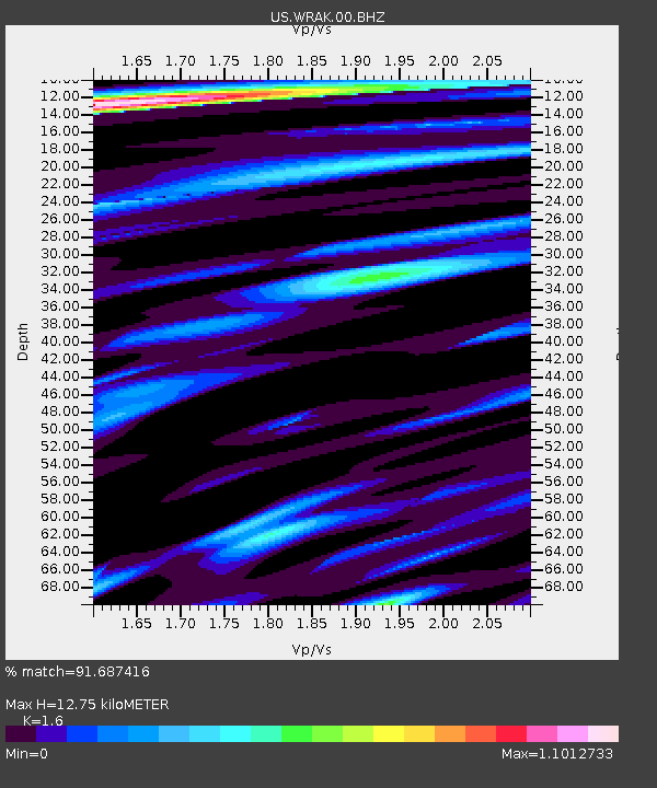
| Estimated Moho Depth: |
12.75 km |
| Estimated Crust Vp/Vs: |
1.60 |
| Assumed Crust Vp: |
6.597 km/s |
| Estimated Crust Vs: |
4.123 km/s |
| Estimated Crust Poisson's Ratio: |
0.18 |
|
| Radial Match: |
91.687416 % |
| Radial Bump: |
400 |
| Transverse Match: |
78.22436 % |
| Transverse Bump: |
400 |
| SOD ConfigId: |
558545 |
| Insert Time: |
2013-09-18 19:16:22.121 +0000 |
| GWidth: |
2.5 |
| Max Bumps: |
400 |
| Tol: |
0.001 |
|

Signal To Noise
| Channel | StoN | STA | LTA |
| US:WRAK:00:BHZ:20110603T00:14:12.374983Z | 20.769924 | 2.6219886E-6 | 1.262397E-7 |
| US:WRAK:00:BH1:20110603T00:14:12.374983Z | 11.563845 | 6.967019E-7 | 6.02483E-8 |
| US:WRAK:00:BH2:20110603T00:14:12.374983Z | 7.536396 | 9.876544E-7 | 1.310513E-7 |
| Arrivals |
| Ps | 1.2 SECOND |
| PpPs | 4.7 SECOND |
| PsPs/PpSs | 6.0 SECOND |


