You are here: Home > Network List > US - United States National Seismic Network Stations List
> Station HAWA Hanford, Washington, USA > Earthquake Result Viewer
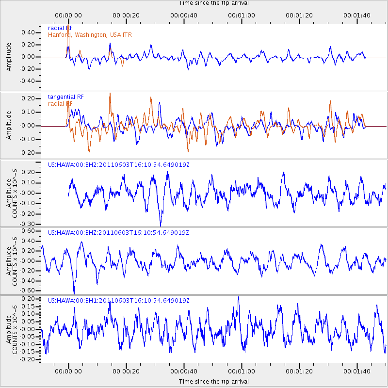
HAWA Hanford, Washington, USA - Earthquake Result Viewer
*The percent match for this event was below the threshold and hence no stack was calculated.
| Earthquake location: |
Eastern Honshu, Japan |
| Earthquake latitude/longitude: |
37.1/140.9 |
| Earthquake time(UTC): |
2011/06/03 (154) 16:00:15 GMT |
| Earthquake Depth: |
17 km |
| Earthquake Magnitude: |
5.5 MW, 5.7 MB |
| Earthquake Catalog/Contributor: |
NEIC PDE/NEIC PDE-M |
|
| Network: |
US United States National Seismic Network |
| Station: |
HAWA Hanford, Washington, USA |
| Lat/Lon: |
46.39 N/119.53 W |
| Elevation: |
364 m |
|
| Distance: |
70.0 deg |
| Az: |
46.563 deg |
| Baz: |
302.949 deg |
| Ray Param: |
$rayparam |
*The percent match for this event was below the threshold and hence was not used in the summary stack. |
|
| Radial Match: |
65.23332 % |
| Radial Bump: |
400 |
| Transverse Match: |
59.3507 % |
| Transverse Bump: |
400 |
| SOD ConfigId: |
558545 |
| Insert Time: |
2013-09-18 19:20:12.618 +0000 |
| GWidth: |
2.5 |
| Max Bumps: |
400 |
| Tol: |
0.001 |
|
Signal To Noise
| Channel | StoN | STA | LTA |
| US:HAWA:00:BHZ:20110603T16:10:54.649019Z | 2.0781703 | 2.9390472E-7 | 1.4142475E-7 |
| US:HAWA:00:BH1:20110603T16:10:54.649019Z | 0.72183824 | 6.272214E-8 | 8.689223E-8 |
| US:HAWA:00:BH2:20110603T16:10:54.649019Z | 2.2326515 | 1.5442761E-7 | 6.916781E-8 |
| Arrivals |
| Ps | |
| PpPs | |
| PsPs/PpSs | |


