You are here: Home > Network List > US - United States National Seismic Network Stations List
> Station MSO Missoula, Montana, USA > Earthquake Result Viewer
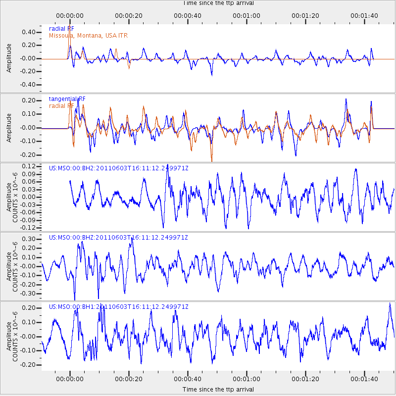
MSO Missoula, Montana, USA - Earthquake Result Viewer
*The percent match for this event was below the threshold and hence no stack was calculated.
| Earthquake location: |
Eastern Honshu, Japan |
| Earthquake latitude/longitude: |
37.1/140.9 |
| Earthquake time(UTC): |
2011/06/03 (154) 16:00:15 GMT |
| Earthquake Depth: |
17 km |
| Earthquake Magnitude: |
5.5 MW, 5.7 MB |
| Earthquake Catalog/Contributor: |
NEIC PDE/NEIC PDE-M |
|
| Network: |
US United States National Seismic Network |
| Station: |
MSO Missoula, Montana, USA |
| Lat/Lon: |
46.83 N/113.94 W |
| Elevation: |
1264 m |
|
| Distance: |
73.0 deg |
| Az: |
43.88 deg |
| Baz: |
306.15 deg |
| Ray Param: |
$rayparam |
*The percent match for this event was below the threshold and hence was not used in the summary stack. |
|
| Radial Match: |
70.22941 % |
| Radial Bump: |
400 |
| Transverse Match: |
74.25855 % |
| Transverse Bump: |
400 |
| SOD ConfigId: |
558545 |
| Insert Time: |
2013-09-18 19:20:42.731 +0000 |
| GWidth: |
2.5 |
| Max Bumps: |
400 |
| Tol: |
0.001 |
|
Signal To Noise
| Channel | StoN | STA | LTA |
| US:MSO:00:BHZ:20110603T16:11:12.249971Z | 1.8278475 | 1.7792651E-7 | 9.73421E-8 |
| US:MSO:00:BH1:20110603T16:11:12.249971Z | 2.0335844 | 1.1974358E-7 | 5.8883018E-8 |
| US:MSO:00:BH2:20110603T16:11:12.249971Z | 2.1697872 | 6.089568E-8 | 2.8065276E-8 |
| Arrivals |
| Ps | |
| PpPs | |
| PsPs/PpSs | |


