You are here: Home > Network List > US - United States National Seismic Network Stations List
> Station WMOK Wichita Mountains, Oklahoma, USA > Earthquake Result Viewer
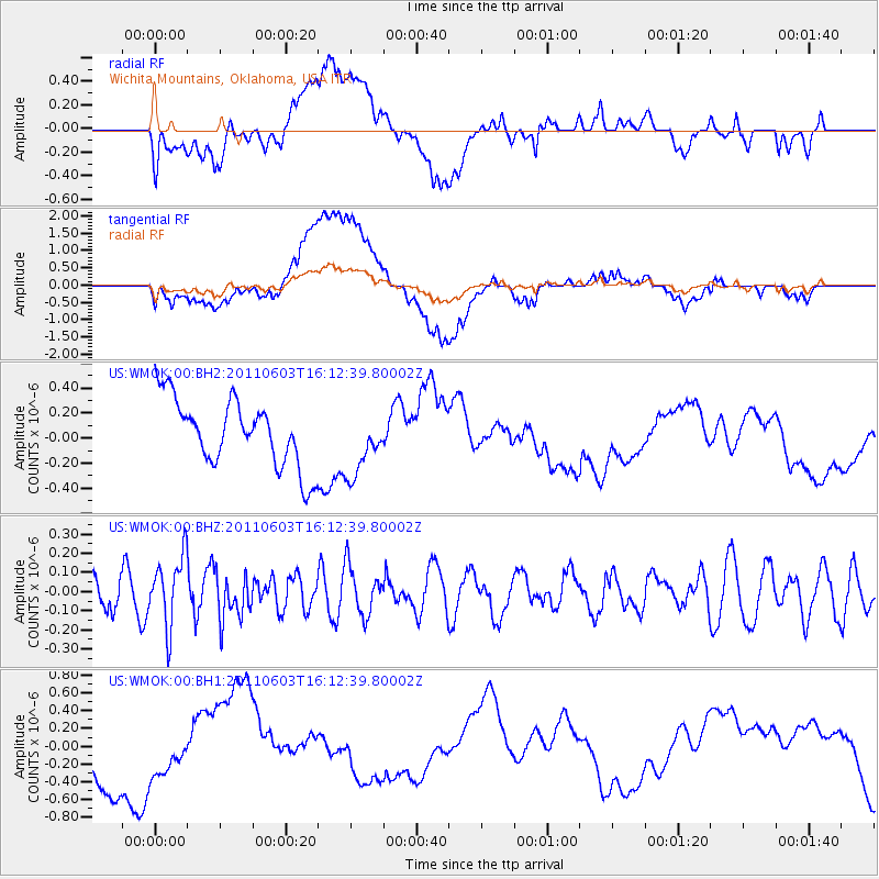
WMOK Wichita Mountains, Oklahoma, USA - Earthquake Result Viewer
*The percent match for this event was below the threshold and hence no stack was calculated.
| Earthquake location: |
Eastern Honshu, Japan |
| Earthquake latitude/longitude: |
37.1/140.9 |
| Earthquake time(UTC): |
2011/06/03 (154) 16:00:15 GMT |
| Earthquake Depth: |
17 km |
| Earthquake Magnitude: |
5.5 MW, 5.7 MB |
| Earthquake Catalog/Contributor: |
NEIC PDE/NEIC PDE-M |
|
| Network: |
US United States National Seismic Network |
| Station: |
WMOK Wichita Mountains, Oklahoma, USA |
| Lat/Lon: |
34.74 N/98.78 W |
| Elevation: |
486 m |
|
| Distance: |
89.5 deg |
| Az: |
45.318 deg |
| Baz: |
316.324 deg |
| Ray Param: |
$rayparam |
*The percent match for this event was below the threshold and hence was not used in the summary stack. |
|
| Radial Match: |
44.858383 % |
| Radial Bump: |
400 |
| Transverse Match: |
40.698845 % |
| Transverse Bump: |
400 |
| SOD ConfigId: |
558545 |
| Insert Time: |
2013-09-18 19:21:12.876 +0000 |
| GWidth: |
2.5 |
| Max Bumps: |
400 |
| Tol: |
0.001 |
|
Signal To Noise
| Channel | StoN | STA | LTA |
| US:WMOK:00:BHZ:20110603T16:12:39.80002Z | 2.8611486 | 1.8146085E-7 | 6.3422384E-8 |
| US:WMOK:00:BH1:20110603T16:12:39.80002Z | 0.8106769 | 3.376477E-7 | 4.1650094E-7 |
| US:WMOK:00:BH2:20110603T16:12:39.80002Z | 0.9671283 | 2.5912811E-7 | 2.679356E-7 |
| Arrivals |
| Ps | |
| PpPs | |
| PsPs/PpSs | |


