You are here: Home > Network List > CN - Canadian National Seismograph Network Stations List
> Station INK INUVIK, N.W.T. > Earthquake Result Viewer
INK INUVIK, N.W.T. - Earthquake Result Viewer

| Earthquake location: |
Hindu Kush Region, Afghanistan |
| Earthquake latitude/longitude: |
36.3/70.9 |
| Earthquake time(UTC): |
2000/07/17 (199) 22:53:47 GMT |
| Earthquake Depth: |
141 km |
| Earthquake Magnitude: |
6.0 MB, 6.4 MW, 6.3 MW |
| Earthquake Catalog/Contributor: |
WHDF/NEIC |
|
| Network: |
CN Canadian National Seismograph Network |
| Station: |
INK INUVIK, N.W.T. |
| Lat/Lon: |
68.31 N/133.52 W |
| Elevation: |
40 m |
|
| Distance: |
74.1 deg |
| Az: |
9.204 deg |
| Baz: |
339.659 deg |
| Ray Param: |
0.052182063 |
| Estimated Moho Depth: |
23.0 km |
| Estimated Crust Vp/Vs: |
2.08 |
| Assumed Crust Vp: |
6.171 km/s |
| Estimated Crust Vs: |
2.967 km/s |
| Estimated Crust Poisson's Ratio: |
0.35 |
|
| Radial Match: |
96.85579 % |
| Radial Bump: |
328 |
| Transverse Match: |
93.877045 % |
| Transverse Bump: |
400 |
| SOD ConfigId: |
3744 |
| Insert Time: |
2010-02-27 06:03:25.300 +0000 |
| GWidth: |
2.5 |
| Max Bumps: |
400 |
| Tol: |
0.001 |
|
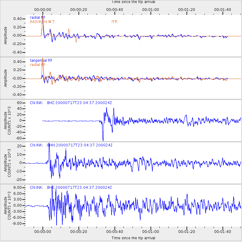
Signal To Noise
| Channel | StoN | STA | LTA |
| CN:INK: :BHN:20000717T23:04:37.200024Z | 31.623545 | 7256.9976 | 229.48083 |
| CN:INK: :BHE:20000717T23:04:37.200024Z | 12.636814 | 2314.4333 | 183.15005 |
| CN:INK: :BHZ:20000717T23:04:37.200024Z | 92.32463 | 19470.229 | 210.88878 |
| Arrivals |
| Ps | 4.1 SECOND |
| PpPs | 11 SECOND |
| PsPs/PpSs | 15 SECOND |


