You are here: Home > Network List > US - United States National Seismic Network Stations List
> Station CBKS Cedar Bluff, Kansas, USA > Earthquake Result Viewer
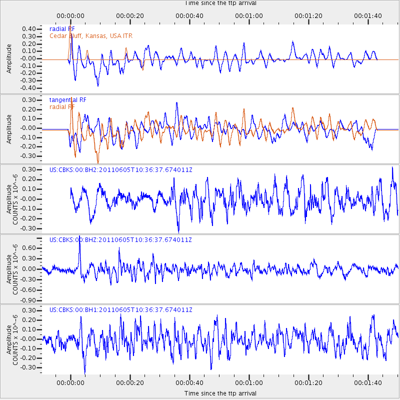
CBKS Cedar Bluff, Kansas, USA - Earthquake Result Viewer
*The percent match for this event was below the threshold and hence no stack was calculated.
| Earthquake location: |
Near Coast Of Central Chile |
| Earthquake latitude/longitude: |
-35.0/-72.2 |
| Earthquake time(UTC): |
2011/06/05 (156) 10:25:15 GMT |
| Earthquake Depth: |
32 km |
| Earthquake Magnitude: |
5.5 MB, 5.6 ML |
| Earthquake Catalog/Contributor: |
NEIC PDE/NEIC PDE-M |
|
| Network: |
US United States National Seismic Network |
| Station: |
CBKS Cedar Bluff, Kansas, USA |
| Lat/Lon: |
38.81 N/99.74 W |
| Elevation: |
677 m |
|
| Distance: |
77.7 deg |
| Az: |
338.299 deg |
| Baz: |
157.135 deg |
| Ray Param: |
$rayparam |
*The percent match for this event was below the threshold and hence was not used in the summary stack. |
|
| Radial Match: |
66.86907 % |
| Radial Bump: |
400 |
| Transverse Match: |
64.653404 % |
| Transverse Bump: |
400 |
| SOD ConfigId: |
558545 |
| Insert Time: |
2013-09-18 19:23:12.001 +0000 |
| GWidth: |
2.5 |
| Max Bumps: |
400 |
| Tol: |
0.001 |
|
Signal To Noise
| Channel | StoN | STA | LTA |
| US:CBKS:00:BHZ:20110605T10:36:37.674011Z | 4.0031424 | 2.586941E-7 | 6.462276E-8 |
| US:CBKS:00:BH1:20110605T10:36:37.674011Z | 1.5945506 | 1.2098816E-7 | 7.5876024E-8 |
| US:CBKS:00:BH2:20110605T10:36:37.674011Z | 0.8313611 | 6.680627E-8 | 8.035771E-8 |
| Arrivals |
| Ps | |
| PpPs | |
| PsPs/PpSs | |


