You are here: Home > Network List > IU - Global Seismograph Network (GSN - IRIS/USGS) Stations List
> Station GUMO Guam, Mariana Islands > Earthquake Result Viewer
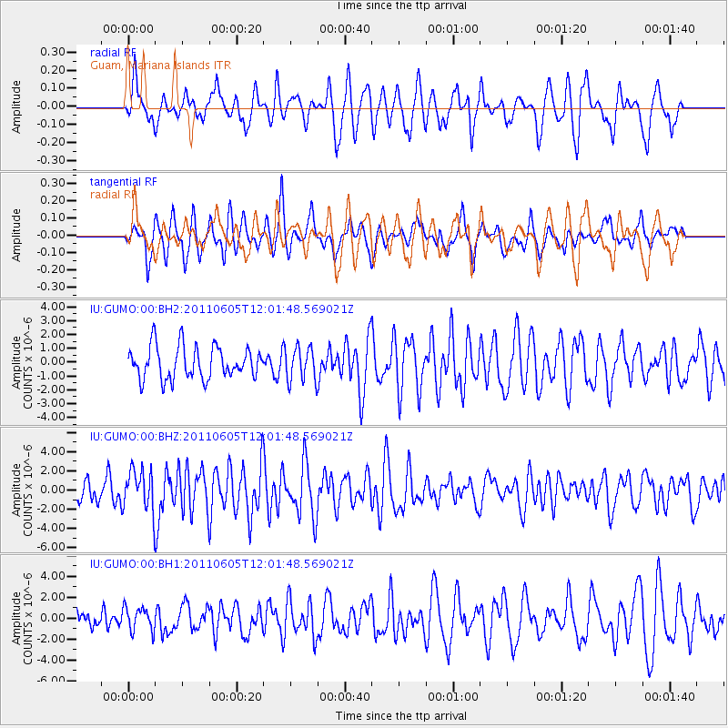
GUMO Guam, Mariana Islands - Earthquake Result Viewer
*The percent match for this event was below the threshold and hence no stack was calculated.
| Earthquake location: |
West Of Macquarie Island |
| Earthquake latitude/longitude: |
-55.8/146.6 |
| Earthquake time(UTC): |
2011/06/05 (156) 11:51:12 GMT |
| Earthquake Depth: |
3.0 km |
| Earthquake Magnitude: |
5.9 MB, 6.4 MS, 6.4 MW, 6.4 MW |
| Earthquake Catalog/Contributor: |
WHDF/NEIC |
|
| Network: |
IU Global Seismograph Network (GSN - IRIS/USGS) |
| Station: |
GUMO Guam, Mariana Islands |
| Lat/Lon: |
13.59 N/144.87 E |
| Elevation: |
170 m |
|
| Distance: |
69.2 deg |
| Az: |
358.178 deg |
| Baz: |
178.943 deg |
| Ray Param: |
$rayparam |
*The percent match for this event was below the threshold and hence was not used in the summary stack. |
|
| Radial Match: |
67.02056 % |
| Radial Bump: |
379 |
| Transverse Match: |
57.88467 % |
| Transverse Bump: |
365 |
| SOD ConfigId: |
558545 |
| Insert Time: |
2013-09-18 19:25:40.142 +0000 |
| GWidth: |
2.5 |
| Max Bumps: |
400 |
| Tol: |
0.001 |
|
Signal To Noise
| Channel | StoN | STA | LTA |
| IU:GUMO:00:BHZ:20110605T12:01:48.569021Z | 2.2600598 | 2.1552635E-6 | 9.5363123E-7 |
| IU:GUMO:00:BH1:20110605T12:01:48.569021Z | 1.101866 | 1.1372911E-6 | 1.0321501E-6 |
| IU:GUMO:00:BH2:20110605T12:01:48.569021Z | 1.0527016 | 1.2241206E-6 | 1.1628373E-6 |
| Arrivals |
| Ps | |
| PpPs | |
| PsPs/PpSs | |


