You are here: Home > Network List > US - United States National Seismic Network Stations List
> Station EGMT Eagleton, Montana, USA > Earthquake Result Viewer
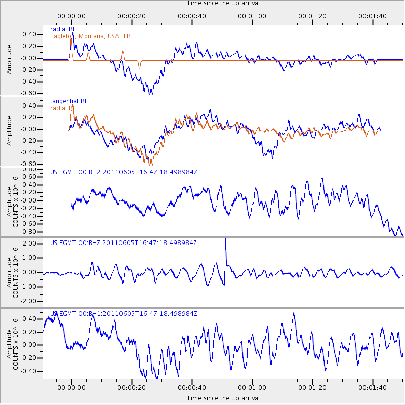
EGMT Eagleton, Montana, USA - Earthquake Result Viewer
*The percent match for this event was below the threshold and hence no stack was calculated.
| Earthquake location: |
Fiji Islands Region |
| Earthquake latitude/longitude: |
-15.1/-177.9 |
| Earthquake time(UTC): |
2011/06/05 (156) 16:35:04 GMT |
| Earthquake Depth: |
13 km |
| Earthquake Magnitude: |
5.5 MB, 5.8 MS, 5.9 MW, 5.8 MW |
| Earthquake Catalog/Contributor: |
WHDF/NEIC |
|
| Network: |
US United States National Seismic Network |
| Station: |
EGMT Eagleton, Montana, USA |
| Lat/Lon: |
48.02 N/109.75 W |
| Elevation: |
1055 m |
|
| Distance: |
87.2 deg |
| Az: |
38.591 deg |
| Baz: |
243.823 deg |
| Ray Param: |
$rayparam |
*The percent match for this event was below the threshold and hence was not used in the summary stack. |
|
| Radial Match: |
60.26074 % |
| Radial Bump: |
400 |
| Transverse Match: |
51.401688 % |
| Transverse Bump: |
400 |
| SOD ConfigId: |
558545 |
| Insert Time: |
2013-09-18 19:27:50.366 +0000 |
| GWidth: |
2.5 |
| Max Bumps: |
400 |
| Tol: |
0.001 |
|
Signal To Noise
| Channel | StoN | STA | LTA |
| US:EGMT:00:BHZ:20110605T16:47:18.498984Z | 2.694781 | 1.5059929E-7 | 5.5885543E-8 |
| US:EGMT:00:BH1:20110605T16:47:18.498984Z | 0.25677037 | 1.0615041E-7 | 4.13406E-7 |
| US:EGMT:00:BH2:20110605T16:47:18.498984Z | 1.4370221 | 2.4570537E-7 | 1.7098232E-7 |
| Arrivals |
| Ps | |
| PpPs | |
| PsPs/PpSs | |


