You are here: Home > Network List > CN - Canadian National Seismograph Network Stations List
> Station INK INUVIK, N.W.T. > Earthquake Result Viewer
INK INUVIK, N.W.T. - Earthquake Result Viewer
| Earthquake location: |
Hindu Kush Region, Afghanistan |
| Earthquake latitude/longitude: |
36.0/70.7 |
| Earthquake time(UTC): |
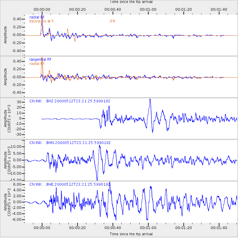
2000/05/12 (133) 23:10:29 GMT |
| Earthquake Depth: |
108 km |
| Earthquake Magnitude: |
6.2 MB, 6.3 MW, 6.3 MW |
| Earthquake Catalog/Contributor: |
WHDF/NEIC |
|
| Network: |
CN Canadian National Seismograph Network |
| Station: |
INK INUVIK, N.W.T. |
| Lat/Lon: |
68.31 N/133.52 W |
| Elevation: |
40 m |
|
| Distance: |
74.5 deg |
| Az: |
9.093 deg |
| Baz: |
339.83 deg |
| Ray Param: |
0.052054532 |
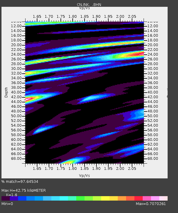
| Estimated Moho Depth: |
42.75 km |
| Estimated Crust Vp/Vs: |
1.60 |
| Assumed Crust Vp: |
6.171 km/s |
| Estimated Crust Vs: |
3.857 km/s |
| Estimated Crust Poisson's Ratio: |
0.18 |
|
| Radial Match: |
97.64534 % |
| Radial Bump: |
337 |
| Transverse Match: |
94.67596 % |
| Transverse Bump: |
400 |
| SOD ConfigId: |
3744 |
| Insert Time: |
2010-02-27 06:03:39.225 +0000 |
| GWidth: |
2.5 |
| Max Bumps: |
400 |
| Tol: |
0.001 |
|
Signal To Noise
| Channel | StoN | STA | LTA |
| CN:INK: :BHN:20000512T23:21:25.599019Z | 8.187926 | 2616.6492 | 319.5741 |
| CN:INK: :BHE:20000512T23:21:25.599019Z | 2.668782 | 659.42456 | 247.08821 |
| CN:INK: :BHZ:20000512T23:21:25.599019Z | 17.741661 | 7500.5664 | 422.76575 |
| Arrivals |
| Ps | 4.3 SECOND |
| PpPs | 17 SECOND |
| PsPs/PpSs | 22 SECOND |


