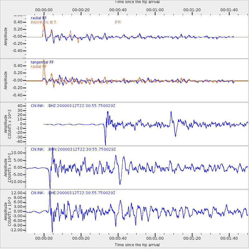
INK INUVIK, N.W.T. - Earthquake Result Viewer
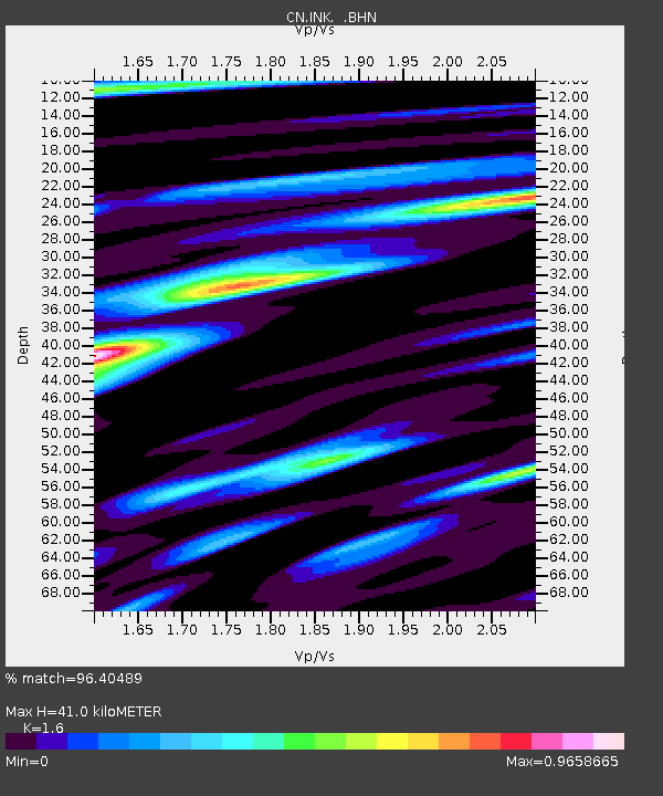
Earthquake location: Near Coast Of Chiapas, Mexico
Earthquake latitude/longitude: 15.0/-92.4
Earthquake time(UTC): 2000/03/12 (072) 22:21:30 GMT
Earthquake Depth: 62 km
Earthquake Magnitude: 5.5 MB, 5.8 MS, 6.3 MW, 5.4 MD
Earthquake Catalog/Contributor: WHDF/NEIC
Network: CN Canadian National Seismograph Network
Station: INK INUVIK, N.W.T.
Lat/Lon: 68.31 N/133.52 W
Elevation: 40 m
Distance: 59.4 deg
Az: 343.51 deg
Baz: 132.45 deg
Ray Param: 0.0620656
Estimated Moho Depth: 41.0 km
Estimated Crust Vp/Vs: 1.60
Assumed Crust Vp: 6.171 km/s
Estimated Crust Vs: 3.857 km/s
Estimated Crust Poisson's Ratio: 0.18
Radial Match: 96.40489 %
Radial Bump: 372
Transverse Match: 85.44414 %
Transverse Bump: 400
SOD ConfigId: 3744
Insert Time: 2010-02-27 06:03:44.610 +0000
GWidth: 2.5
Max Bumps: 400
Tol: 0.001

Signal To Noise

ChannelStoNSTALTA
CN:INK: :BHN:20000312T22:30:55.750029Z7.20165065386.621747.97034
CN:INK: :BHE:20000312T22:30:55.750029Z9.7784575121.9834523.80286
CN:INK: :BHZ:20000312T22:30:55.750029Z24.31214515312.321629.8219
Arrivals
Ps4.2 SECOND
PpPs16 SECOND
PsPs/PpSs21 SECOND