You are here: Home > Network List > US - United States National Seismic Network Stations List
> Station HAWA Hanford, Washington, USA > Earthquake Result Viewer
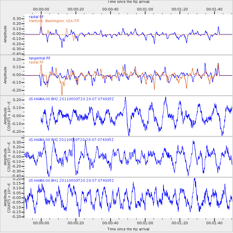
HAWA Hanford, Washington, USA - Earthquake Result Viewer
*The percent match for this event was below the threshold and hence no stack was calculated.
| Earthquake location: |
Kermadec Islands, New Zealand |
| Earthquake latitude/longitude: |
-30.4/-178.1 |
| Earthquake time(UTC): |
2011/06/09 (160) 20:16:28 GMT |
| Earthquake Depth: |
31 km |
| Earthquake Magnitude: |
5.6 MW, 5.6 MW |
| Earthquake Catalog/Contributor: |
NEIC PDE/NEIC PDE-M |
|
| Network: |
US United States National Seismic Network |
| Station: |
HAWA Hanford, Washington, USA |
| Lat/Lon: |
46.39 N/119.53 W |
| Elevation: |
364 m |
|
| Distance: |
92.9 deg |
| Az: |
36.233 deg |
| Baz: |
227.534 deg |
| Ray Param: |
$rayparam |
*The percent match for this event was below the threshold and hence was not used in the summary stack. |
|
| Radial Match: |
66.10035 % |
| Radial Bump: |
331 |
| Transverse Match: |
69.12218 % |
| Transverse Bump: |
400 |
| SOD ConfigId: |
558545 |
| Insert Time: |
2013-09-18 19:37:09.637 +0000 |
| GWidth: |
2.5 |
| Max Bumps: |
400 |
| Tol: |
0.001 |
|
Signal To Noise
| Channel | StoN | STA | LTA |
| US:HAWA:00:BHZ:20110609T20:29:07.074995Z | 3.0766854 | 2.1137151E-7 | 6.870104E-8 |
| US:HAWA:00:BH1:20110609T20:29:07.074995Z | 1.5369828 | 7.6973826E-8 | 5.0081127E-8 |
| US:HAWA:00:BH2:20110609T20:29:07.074995Z | 1.1296659 | 6.2366524E-8 | 5.5207938E-8 |
| Arrivals |
| Ps | |
| PpPs | |
| PsPs/PpSs | |


