You are here: Home > Network List > US - United States National Seismic Network Stations List
> Station ERPA Erie, Pennsylvania, USA > Earthquake Result Viewer
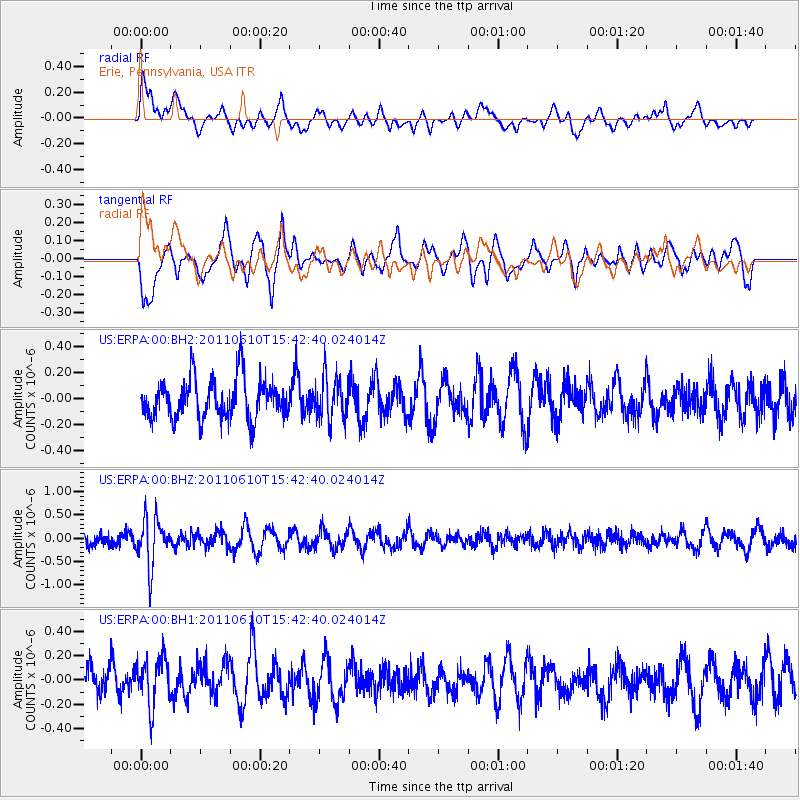
ERPA Erie, Pennsylvania, USA - Earthquake Result Viewer
*The percent match for this event was below the threshold and hence no stack was calculated.
| Earthquake location: |
South Pacific Ocean |
| Earthquake latitude/longitude: |
-6.7/-122.7 |
| Earthquake time(UTC): |
2011/06/10 (161) 15:32:48 GMT |
| Earthquake Depth: |
10 km |
| Earthquake Magnitude: |
5.5 MB |
| Earthquake Catalog/Contributor: |
NEIC PDE/NEIC PDE-M |
|
| Network: |
US United States National Seismic Network |
| Station: |
ERPA Erie, Pennsylvania, USA |
| Lat/Lon: |
42.12 N/79.99 W |
| Elevation: |
306 m |
|
| Distance: |
62.3 deg |
| Az: |
34.778 deg |
| Baz: |
229.591 deg |
| Ray Param: |
$rayparam |
*The percent match for this event was below the threshold and hence was not used in the summary stack. |
|
| Radial Match: |
59.98058 % |
| Radial Bump: |
400 |
| Transverse Match: |
59.953205 % |
| Transverse Bump: |
400 |
| SOD ConfigId: |
558545 |
| Insert Time: |
2013-09-18 19:40:17.074 +0000 |
| GWidth: |
2.5 |
| Max Bumps: |
400 |
| Tol: |
0.001 |
|
Signal To Noise
| Channel | StoN | STA | LTA |
| US:ERPA:00:BHZ:20110610T15:42:40.024014Z | 2.3581831 | 4.911707E-7 | 2.0828352E-7 |
| US:ERPA:00:BH1:20110610T15:42:40.024014Z | 1.7031614 | 1.9582274E-7 | 1.1497603E-7 |
| US:ERPA:00:BH2:20110610T15:42:40.024014Z | 1.0815748 | 1.6698769E-7 | 1.543931E-7 |
| Arrivals |
| Ps | |
| PpPs | |
| PsPs/PpSs | |


