You are here: Home > Network List > IU - Global Seismograph Network (GSN - IRIS/USGS) Stations List
> Station GNI Garni, Armenia > Earthquake Result Viewer
GNI Garni, Armenia - Earthquake Result Viewer
| Earthquake location: |
Northern Molucca Sea |
| Earthquake latitude/longitude: |
2.5/126.5 |
| Earthquake time(UTC): |
2011/06/13 (164) 14:31:22 GMT |
| Earthquake Depth: |
61 km |
| Earthquake Magnitude: |
6.4 MB, 6.4 MW, 6.4 MW |
| Earthquake Catalog/Contributor: |
WHDF/NEIC |
|
| Network: |
IU Global Seismograph Network (GSN - IRIS/USGS) |
| Station: |
GNI Garni, Armenia |
| Lat/Lon: |
40.15 N/44.74 E |
| Elevation: |
1609 m |
|
| Distance: |
82.0 deg |
| Az: |
310.015 deg |
| Baz: |
93.417 deg |
| Ray Param: |
0.047041282 |
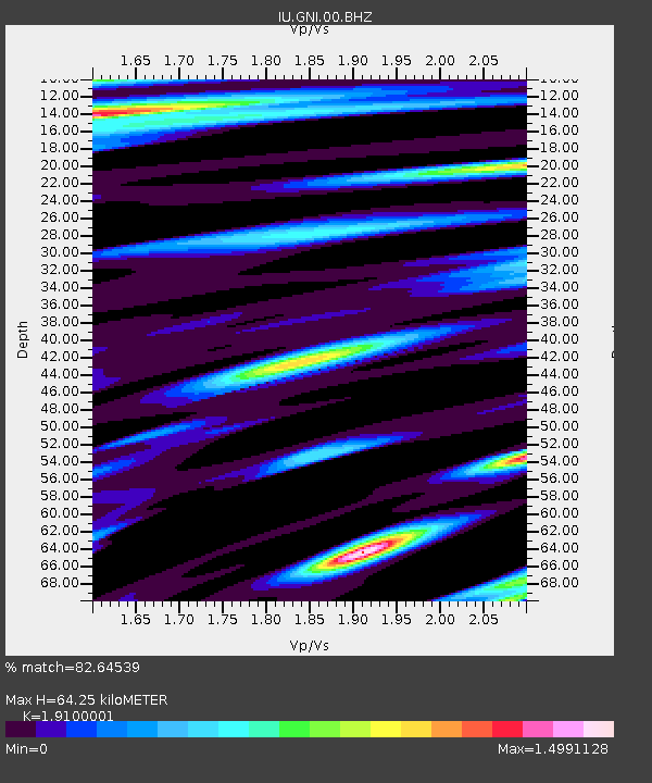
| Estimated Moho Depth: |
64.25 km |
| Estimated Crust Vp/Vs: |
1.91 |
| Assumed Crust Vp: |
6.291 km/s |
| Estimated Crust Vs: |
3.294 km/s |
| Estimated Crust Poisson's Ratio: |
0.31 |
|
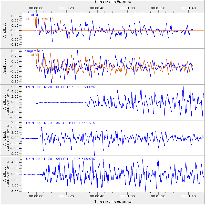
| Radial Match: |
82.64539 % |
| Radial Bump: |
400 |
| Transverse Match: |
86.491516 % |
| Transverse Bump: |
400 |
| SOD ConfigId: |
558545 |
| Insert Time: |
2013-09-18 19:46:24.351 +0000 |
| GWidth: |
2.5 |
| Max Bumps: |
400 |
| Tol: |
0.001 |
|
Signal To Noise
| Channel | StoN | STA | LTA |
| IU:GNI:00:BHZ:20110613T14:43:05.568979Z | 32.54924 | 2.8834183E-6 | 8.858635E-8 |
| IU:GNI:00:BH1:20110613T14:43:05.568979Z | 2.982285 | 1.968068E-7 | 6.599195E-8 |
| IU:GNI:00:BH2:20110613T14:43:05.568979Z | 5.1934485 | 6.073601E-7 | 1.16947355E-7 |
| Arrivals |
| Ps | 9.5 SECOND |
| PpPs | 29 SECOND |
| PsPs/PpSs | 39 SECOND |


