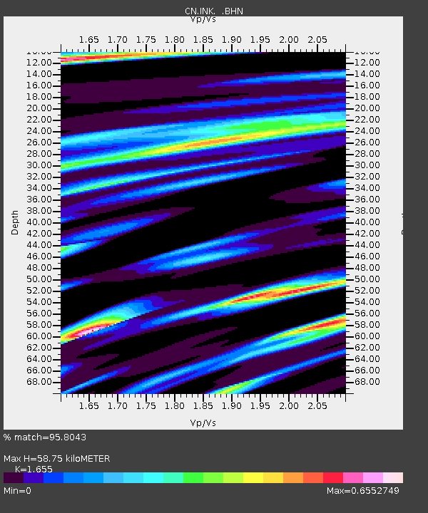
INK INUVIK, N.W.T. - Earthquake Result Viewer
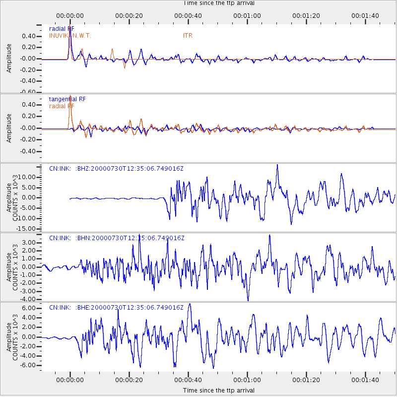
Earthquake location: Southeast Of Honshu, Japan
Earthquake latitude/longitude: 33.9/139.4
Earthquake time(UTC): 2000/07/30 (212) 12:25:45 GMT
Earthquake Depth: 10 km
Earthquake Magnitude: 6.0 MB, 6.5 MS, 6.5 MW, 6.5 MW
Earthquake Catalog/Contributor: WHDF/NEIC
Network: CN Canadian National Seismograph Network
Station: INK INUVIK, N.W.T.
Lat/Lon: 68.31 N/133.52 W
Elevation: 40 m
Distance: 57.9 deg
Az: 25.989 deg
Baz: 281.394 deg
Ray Param: 0.06317788
Estimated Moho Depth: 58.75 km
Estimated Crust Vp/Vs: 1.65
Assumed Crust Vp: 6.171 km/s
Estimated Crust Vs: 3.729 km/s
Estimated Crust Poisson's Ratio: 0.21
Radial Match: 95.8043 %
Radial Bump: 400
Transverse Match: 84.30005 %
Transverse Bump: 400
SOD ConfigId: 3744
Insert Time: 2010-02-27 06:04:22.082 +0000
GWidth: 2.5
Max Bumps: 400
Tol: 0.001

Signal To Noise

ChannelStoNSTALTA
CN:INK: :BHN:20000730T12:35:06.749016Z1.9625399335.1746170.78612
CN:INK: :BHE:20000730T12:35:06.749016Z10.5099621384.3389131.71683
CN:INK: :BHZ:20000730T12:35:06.749016Z18.2422873458.1785189.56935
Arrivals
Ps6.5 SECOND
PpPs24 SECOND
PsPs/PpSs31 SECOND