You are here: Home > Network List > IU - Global Seismograph Network (GSN - IRIS/USGS) Stations List
> Station MA2 Magadan, Russia > Earthquake Result Viewer
MA2 Magadan, Russia - Earthquake Result Viewer
| Earthquake location: |
Northern Molucca Sea |
| Earthquake latitude/longitude: |
2.5/126.5 |
| Earthquake time(UTC): |
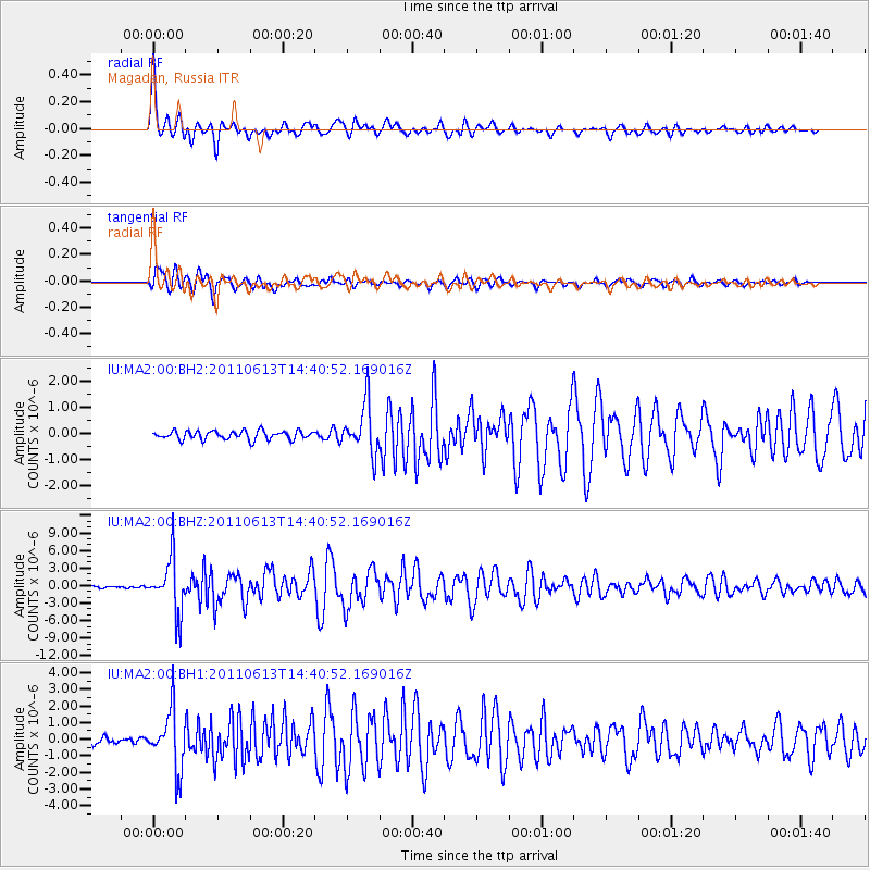
2011/06/13 (164) 14:31:22 GMT |
| Earthquake Depth: |
61 km |
| Earthquake Magnitude: |
6.4 MB, 6.4 MW, 6.4 MW |
| Earthquake Catalog/Contributor: |
WHDF/NEIC |
|
| Network: |
IU Global Seismograph Network (GSN - IRIS/USGS) |
| Station: |
MA2 Magadan, Russia |
| Lat/Lon: |
59.58 N/150.77 E |
| Elevation: |
339 m |
|
| Distance: |
59.9 deg |
| Az: |
14.01 deg |
| Baz: |
208.375 deg |
| Ray Param: |
0.06170736 |
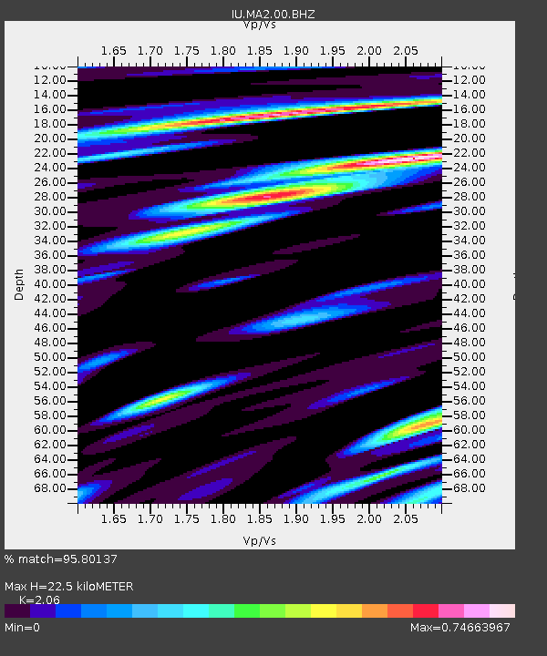
| Estimated Moho Depth: |
22.5 km |
| Estimated Crust Vp/Vs: |
2.06 |
| Assumed Crust Vp: |
6.134 km/s |
| Estimated Crust Vs: |
2.978 km/s |
| Estimated Crust Poisson's Ratio: |
0.35 |
|
| Radial Match: |
95.80137 % |
| Radial Bump: |
400 |
| Transverse Match: |
93.01885 % |
| Transverse Bump: |
400 |
| SOD ConfigId: |
558545 |
| Insert Time: |
2013-09-18 19:46:40.546 +0000 |
| GWidth: |
2.5 |
| Max Bumps: |
400 |
| Tol: |
0.001 |
|
Signal To Noise
| Channel | StoN | STA | LTA |
| IU:MA2:00:BHZ:20110613T14:40:52.169016Z | 24.619017 | 4.586473E-6 | 1.8629798E-7 |
| IU:MA2:00:BH1:20110613T14:40:52.169016Z | 8.619402 | 1.7453383E-6 | 2.0248949E-7 |
| IU:MA2:00:BH2:20110613T14:40:52.169016Z | 5.6670985 | 9.324046E-7 | 1.6452945E-7 |
| Arrivals |
| Ps | 4.0 SECOND |
| PpPs | 11 SECOND |
| PsPs/PpSs | 15 SECOND |


