You are here: Home > Network List > US - United States National Seismic Network Stations List
> Station EGMT Eagleton, Montana, USA > Earthquake Result Viewer
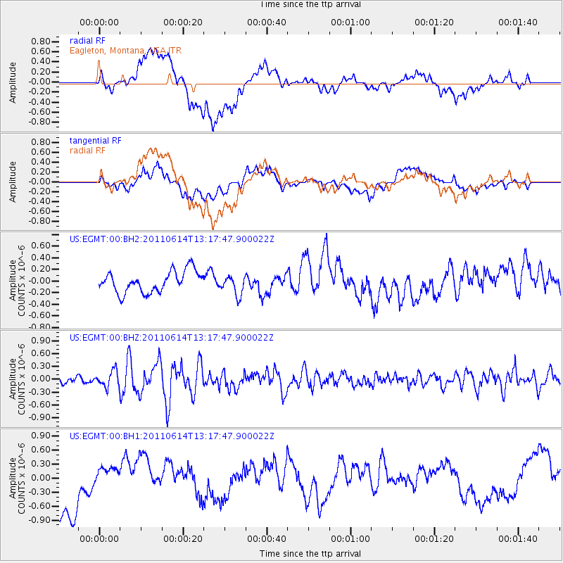
EGMT Eagleton, Montana, USA - Earthquake Result Viewer
*The percent match for this event was below the threshold and hence no stack was calculated.
| Earthquake location: |
Off East Coast Of Honshu, Japan |
| Earthquake latitude/longitude: |
37.7/143.5 |
| Earthquake time(UTC): |
2011/06/14 (165) 13:06:52 GMT |
| Earthquake Depth: |
14 km |
| Earthquake Magnitude: |
5.7 MW, 5.7 MB, 5.8 MW |
| Earthquake Catalog/Contributor: |
NEIC PDE/NEIC PDE-M |
|
| Network: |
US United States National Seismic Network |
| Station: |
EGMT Eagleton, Montana, USA |
| Lat/Lon: |
48.02 N/109.75 W |
| Elevation: |
1055 m |
|
| Distance: |
72.6 deg |
| Az: |
42.342 deg |
| Baz: |
307.29 deg |
| Ray Param: |
$rayparam |
*The percent match for this event was below the threshold and hence was not used in the summary stack. |
|
| Radial Match: |
44.75484 % |
| Radial Bump: |
400 |
| Transverse Match: |
33.965237 % |
| Transverse Bump: |
400 |
| SOD ConfigId: |
558545 |
| Insert Time: |
2013-09-18 19:51:51.478 +0000 |
| GWidth: |
2.5 |
| Max Bumps: |
400 |
| Tol: |
0.001 |
|
Signal To Noise
| Channel | StoN | STA | LTA |
| US:EGMT:00:BHZ:20110614T13:17:47.900022Z | 1.9650313 | 1.9175806E-7 | 9.758525E-8 |
| US:EGMT:00:BH1:20110614T13:17:47.900022Z | 0.74029493 | 3.2332602E-7 | 4.3675294E-7 |
| US:EGMT:00:BH2:20110614T13:17:47.900022Z | 0.95143735 | 1.7309756E-7 | 1.8193269E-7 |
| Arrivals |
| Ps | |
| PpPs | |
| PsPs/PpSs | |


