MAJO Matsushiro, Japan - Earthquake Result Viewer
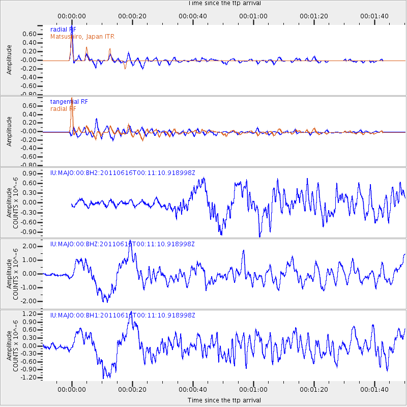
Earthquake location: New Britain Region, P.N.G.
Earthquake latitude/longitude: -5.9/151.0
Earthquake time(UTC): 2011/06/16 (167) 00:03:35 GMT
Earthquake Depth: 16 km
Earthquake Magnitude: 6.1 MB, 6.5 MS, 6.3 MW, 6.2 MW
Earthquake Catalog/Contributor: WHDF/NEIC
Network: IU Global Seismograph Network (GSN - IRIS/USGS)
Station: MAJO Matsushiro, Japan
Lat/Lon: 36.55 N/138.20 E
Elevation: 405 m
Distance: 43.9 deg
Az: 345.056 deg
Baz: 161.426 deg
Ray Param: 0.07221588
Estimated Moho Depth: 50.0 km
Estimated Crust Vp/Vs: 1.60
Assumed Crust Vp: 6.461 km/s
Estimated Crust Vs: 4.038 km/s
Estimated Crust Poisson's Ratio: 0.18
Radial Match: 91.8372 %
Radial Bump: 400
Transverse Match: 79.43961 %
Transverse Bump: 400
SOD ConfigId: 558545
Insert Time: 2013-09-18 19:56:57.052 +0000
GWidth: 2.5
Max Bumps: 400
Tol: 0.001

Signal To Noise

ChannelStoNSTALTA
IU:MAJO:00:BHZ:20110616T00:11:10.918998Z12.4928547.9418334E-76.357101E-8
IU:MAJO:00:BH1:20110616T00:11:10.918998Z5.6303224.1935274E-77.4481136E-8
IU:MAJO:00:BH2:20110616T00:11:10.918998Z2.51860861.7039063E-76.7652685E-8
Arrivals
Ps5.0 SECOND
PpPs19 SECOND
PsPs/PpSs24 SECOND