You are here: Home > Network List > 3C - Arizona Rapid Array Array Mobilization Program Stations List
> Station DUN2 Lazy B, AZ, USA > Earthquake Result Viewer
DUN2 Lazy B, AZ, USA - Earthquake Result Viewer
| Earthquake location: |
Tonga Islands |
| Earthquake latitude/longitude: |
-21.4/-173.3 |
| Earthquake time(UTC): |
2014/09/04 (247) 05:33:46 GMT |
| Earthquake Depth: |
12 km |
| Earthquake Magnitude: |
6.0 MWB |
| Earthquake Catalog/Contributor: |
NEIC PDE/NEIC COMCAT |
|
| Network: |
3C Arizona Rapid Array Array Mobilization Program |
| Station: |
DUN2 Lazy B, AZ, USA |
| Lat/Lon: |
32.55 N/109.17 W |
| Elevation: |
1394 m |
|
| Distance: |
81.4 deg |
| Az: |
50.201 deg |
| Baz: |
237.969 deg |
| Ray Param: |
0.0476186 |
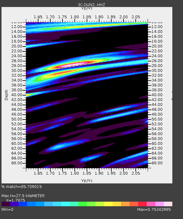
| Estimated Moho Depth: |
27.5 km |
| Estimated Crust Vp/Vs: |
1.79 |
| Assumed Crust Vp: |
6.276 km/s |
| Estimated Crust Vs: |
3.511 km/s |
| Estimated Crust Poisson's Ratio: |
0.27 |
|
| Radial Match: |
85.709015 % |
| Radial Bump: |
400 |
| Transverse Match: |
75.22904 % |
| Transverse Bump: |
400 |
| SOD ConfigId: |
3390531 |
| Insert Time: |
2019-04-13 20:21:41.525 +0000 |
| GWidth: |
2.5 |
| Max Bumps: |
400 |
| Tol: |
0.001 |
|

Signal To Noise
| Channel | StoN | STA | LTA |
| 3C:DUN2: :HHZ:20140904T05:45:31.56501Z | 9.462285 | 1.0909534E-6 | 1.1529493E-7 |
| 3C:DUN2: :HHN:20140904T05:45:31.56501Z | 2.8905532 | 2.4312214E-7 | 8.410921E-8 |
| 3C:DUN2: :HHE:20140904T05:45:31.56501Z | 2.093535 | 2.1325367E-7 | 1.01862966E-7 |
| Arrivals |
| Ps | 3.5 SECOND |
| PpPs | 12 SECOND |
| PsPs/PpSs | 15 SECOND |


