You are here: Home > Network List > US - United States National Seismic Network Stations List
> Station EGMT Eagleton, Montana, USA > Earthquake Result Viewer
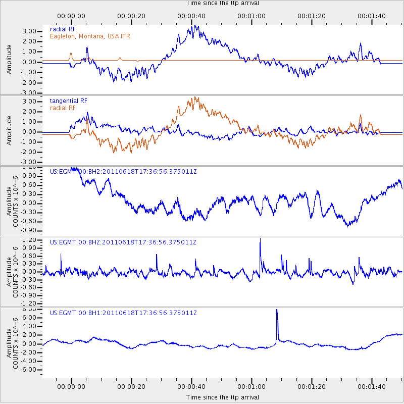
EGMT Eagleton, Montana, USA - Earthquake Result Viewer
*The percent match for this event was below the threshold and hence no stack was calculated.
| Earthquake location: |
Guatemala |
| Earthquake latitude/longitude: |
14.0/-91.6 |
| Earthquake time(UTC): |
2011/06/18 (169) 17:30:19 GMT |
| Earthquake Depth: |
32 km |
| Earthquake Magnitude: |
5.5 MW |
| Earthquake Catalog/Contributor: |
NEIC PDE/NEIC PDE-M |
|
| Network: |
US United States National Seismic Network |
| Station: |
EGMT Eagleton, Montana, USA |
| Lat/Lon: |
48.02 N/109.75 W |
| Elevation: |
1055 m |
|
| Distance: |
37.1 deg |
| Az: |
339.751 deg |
| Baz: |
149.973 deg |
| Ray Param: |
$rayparam |
*The percent match for this event was below the threshold and hence was not used in the summary stack. |
|
| Radial Match: |
56.48992 % |
| Radial Bump: |
400 |
| Transverse Match: |
65.63324 % |
| Transverse Bump: |
400 |
| SOD ConfigId: |
558545 |
| Insert Time: |
2013-09-18 20:03:31.209 +0000 |
| GWidth: |
2.5 |
| Max Bumps: |
400 |
| Tol: |
0.001 |
|
Signal To Noise
| Channel | StoN | STA | LTA |
| US:EGMT:00:BHZ:20110618T17:36:56.375011Z | 0.70253116 | 9.116098E-8 | 1.2976076E-7 |
| US:EGMT:00:BH1:20110618T17:36:56.375011Z | 1.8557736 | 1.5948601E-6 | 8.594045E-7 |
| US:EGMT:00:BH2:20110618T17:36:56.375011Z | 1.436161 | 5.872736E-7 | 4.0891902E-7 |
| Arrivals |
| Ps | |
| PpPs | |
| PsPs/PpSs | |


