You are here: Home > Network List > IU - Global Seismograph Network (GSN - IRIS/USGS) Stations List
> Station RSSD Black Hills, South Dakota, USA > Earthquake Result Viewer
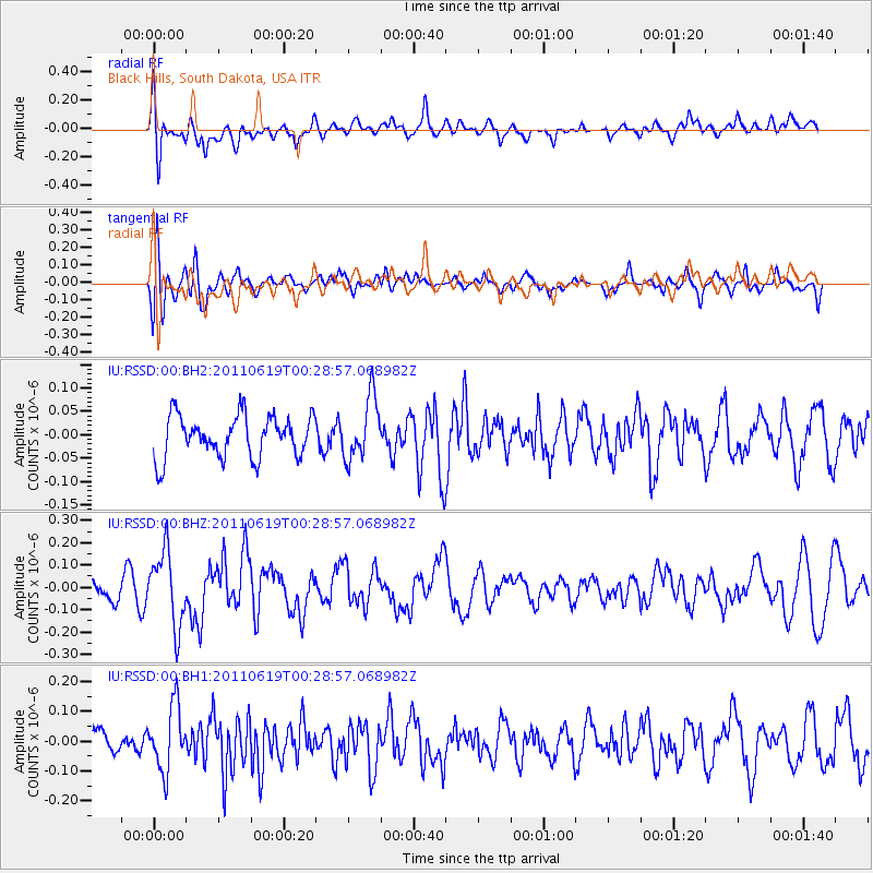
RSSD Black Hills, South Dakota, USA - Earthquake Result Viewer
*The percent match for this event was below the threshold and hence no stack was calculated.
| Earthquake location: |
Near Coast Of Northern Peru |
| Earthquake latitude/longitude: |
-6.0/-81.0 |
| Earthquake time(UTC): |
2011/06/19 (170) 00:20:03 GMT |
| Earthquake Depth: |
10 km |
| Earthquake Magnitude: |
5.6 MW, 5.5 MW |
| Earthquake Catalog/Contributor: |
NEIC PDE/NEIC PDE-M |
|
| Network: |
IU Global Seismograph Network (GSN - IRIS/USGS) |
| Station: |
RSSD Black Hills, South Dakota, USA |
| Lat/Lon: |
44.12 N/104.04 W |
| Elevation: |
2090 m |
|
| Distance: |
54.0 deg |
| Az: |
339.598 deg |
| Baz: |
151.219 deg |
| Ray Param: |
$rayparam |
*The percent match for this event was below the threshold and hence was not used in the summary stack. |
|
| Radial Match: |
58.0385 % |
| Radial Bump: |
400 |
| Transverse Match: |
62.006702 % |
| Transverse Bump: |
400 |
| SOD ConfigId: |
558545 |
| Insert Time: |
2013-09-18 20:04:44.319 +0000 |
| GWidth: |
2.5 |
| Max Bumps: |
400 |
| Tol: |
0.001 |
|
Signal To Noise
| Channel | StoN | STA | LTA |
| IU:RSSD:00:BHZ:20110619T00:28:57.068982Z | 2.4617236 | 1.6641623E-7 | 6.7601505E-8 |
| IU:RSSD:00:BH1:20110619T00:28:57.068982Z | 2.1910408 | 1.0794434E-7 | 4.9266237E-8 |
| IU:RSSD:00:BH2:20110619T00:28:57.068982Z | 1.488637 | 6.6367164E-8 | 4.4582507E-8 |
| Arrivals |
| Ps | |
| PpPs | |
| PsPs/PpSs | |


