You are here: Home > Network List > US - United States National Seismic Network Stations List
> Station MIAR Mount Ida, Arkansas, USA > Earthquake Result Viewer
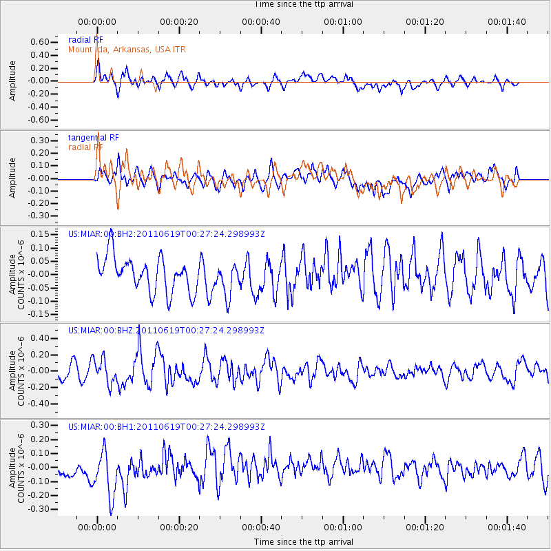
MIAR Mount Ida, Arkansas, USA - Earthquake Result Viewer
*The percent match for this event was below the threshold and hence no stack was calculated.
| Earthquake location: |
Near Coast Of Northern Peru |
| Earthquake latitude/longitude: |
-6.0/-81.0 |
| Earthquake time(UTC): |
2011/06/19 (170) 00:20:03 GMT |
| Earthquake Depth: |
10 km |
| Earthquake Magnitude: |
5.6 MW, 5.5 MW |
| Earthquake Catalog/Contributor: |
NEIC PDE/NEIC PDE-M |
|
| Network: |
US United States National Seismic Network |
| Station: |
MIAR Mount Ida, Arkansas, USA |
| Lat/Lon: |
34.55 N/93.58 W |
| Elevation: |
207 m |
|
| Distance: |
42.0 deg |
| Az: |
344.392 deg |
| Baz: |
161.082 deg |
| Ray Param: |
$rayparam |
*The percent match for this event was below the threshold and hence was not used in the summary stack. |
|
| Radial Match: |
50.87069 % |
| Radial Bump: |
400 |
| Transverse Match: |
48.359814 % |
| Transverse Bump: |
400 |
| SOD ConfigId: |
558545 |
| Insert Time: |
2013-09-18 20:05:54.429 +0000 |
| GWidth: |
2.5 |
| Max Bumps: |
400 |
| Tol: |
0.001 |
|
Signal To Noise
| Channel | StoN | STA | LTA |
| US:MIAR:00:BHZ:20110619T00:27:24.298993Z | 2.0097578 | 1.4508659E-7 | 7.2191085E-8 |
| US:MIAR:00:BH1:20110619T00:27:24.298993Z | 1.6084297 | 1.9116915E-7 | 1.1885453E-7 |
| US:MIAR:00:BH2:20110619T00:27:24.298993Z | 0.93584985 | 6.107124E-8 | 6.525752E-8 |
| Arrivals |
| Ps | |
| PpPs | |
| PsPs/PpSs | |


