You are here: Home > Network List > II - Global Seismograph Network (GSN - IRIS/IDA) Stations List
> Station WRAB Tennant Creek, NT, Australia > Earthquake Result Viewer
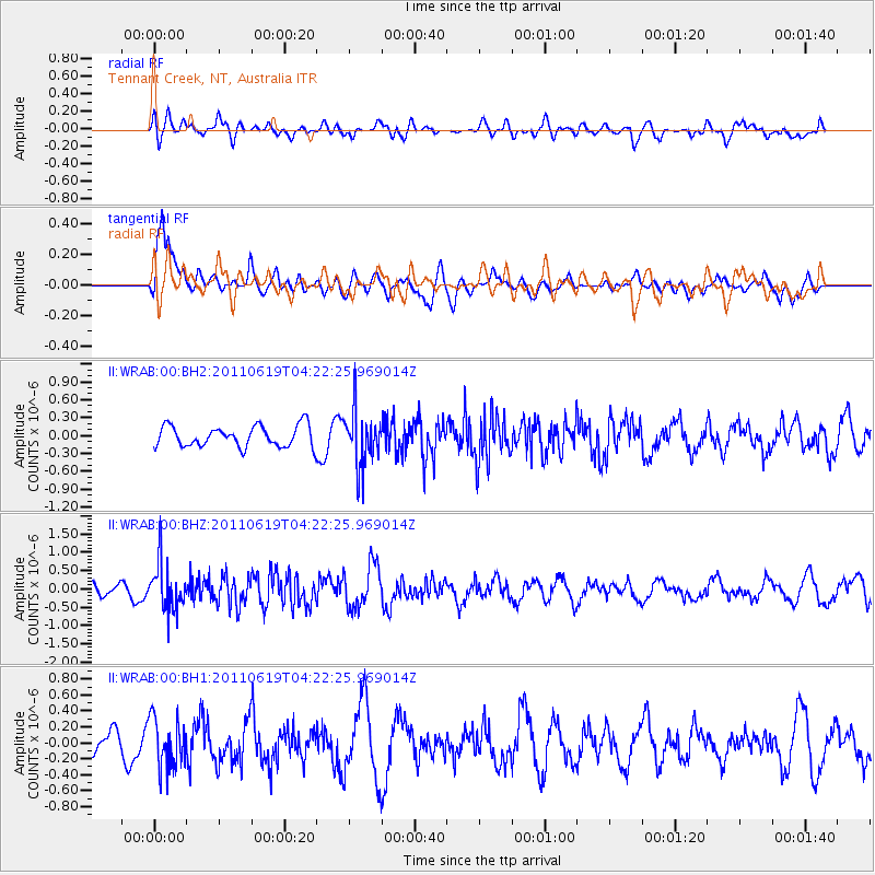
WRAB Tennant Creek, NT, Australia - Earthquake Result Viewer
*The percent match for this event was below the threshold and hence no stack was calculated.
| Earthquake location: |
Southern Sumatra, Indonesia |
| Earthquake latitude/longitude: |
-3.2/101.4 |
| Earthquake time(UTC): |
2011/06/19 (170) 04:15:58 GMT |
| Earthquake Depth: |
57 km |
| Earthquake Magnitude: |
5.6 MB |
| Earthquake Catalog/Contributor: |
NEIC PDE/NEIC PDE-M |
|
| Network: |
II Global Seismograph Network (GSN - IRIS/IDA) |
| Station: |
WRAB Tennant Creek, NT, Australia |
| Lat/Lon: |
19.93 S/134.36 E |
| Elevation: |
366 m |
|
| Distance: |
36.2 deg |
| Az: |
119.845 deg |
| Baz: |
293.004 deg |
| Ray Param: |
$rayparam |
*The percent match for this event was below the threshold and hence was not used in the summary stack. |
|
| Radial Match: |
56.72738 % |
| Radial Bump: |
400 |
| Transverse Match: |
75.37548 % |
| Transverse Bump: |
400 |
| SOD ConfigId: |
558545 |
| Insert Time: |
2013-09-18 20:06:58.349 +0000 |
| GWidth: |
2.5 |
| Max Bumps: |
400 |
| Tol: |
0.001 |
|
Signal To Noise
| Channel | StoN | STA | LTA |
| II:WRAB:00:BHZ:20110619T04:22:25.969014Z | 2.7875602 | 6.323823E-7 | 2.2685872E-7 |
| II:WRAB:00:BH1:20110619T04:22:25.969014Z | 1.5258555 | 3.079806E-7 | 2.0184126E-7 |
| II:WRAB:00:BH2:20110619T04:22:25.969014Z | 2.6351948 | 4.6027407E-7 | 1.7466415E-7 |
| Arrivals |
| Ps | |
| PpPs | |
| PsPs/PpSs | |


