You are here: Home > Network List > IU - Global Seismograph Network (GSN - IRIS/USGS) Stations List
> Station FUNA Funafuti, Tuvalu > Earthquake Result Viewer
FUNA Funafuti, Tuvalu - Earthquake Result Viewer
| Earthquake location: |
Southern Sumatra, Indonesia |
| Earthquake latitude/longitude: |
-3.2/101.4 |
| Earthquake time(UTC): |
2011/06/19 (170) 04:15:58 GMT |
| Earthquake Depth: |
57 km |
| Earthquake Magnitude: |
5.6 MB |
| Earthquake Catalog/Contributor: |
NEIC PDE/NEIC PDE-M |
|
| Network: |
IU Global Seismograph Network (GSN - IRIS/USGS) |
| Station: |
FUNA Funafuti, Tuvalu |
| Lat/Lon: |
8.53 S/179.20 E |
| Elevation: |
20 m |
|
| Distance: |
77.5 deg |
| Az: |
97.967 deg |
| Baz: |
268.553 deg |
| Ray Param: |
0.050166544 |
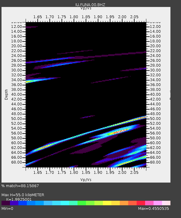
| Estimated Moho Depth: |
55.0 km |
| Estimated Crust Vp/Vs: |
1.99 |
| Assumed Crust Vp: |
4.24 km/s |
| Estimated Crust Vs: |
2.128 km/s |
| Estimated Crust Poisson's Ratio: |
0.33 |
|
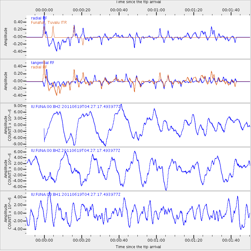
| Radial Match: |
88.15867 % |
| Radial Bump: |
400 |
| Transverse Match: |
54.237045 % |
| Transverse Bump: |
400 |
| SOD ConfigId: |
558545 |
| Insert Time: |
2013-09-18 20:07:05.901 +0000 |
| GWidth: |
2.5 |
| Max Bumps: |
400 |
| Tol: |
0.001 |
|
Signal To Noise
| Channel | StoN | STA | LTA |
| IU:FUNA:00:BHZ:20110619T04:27:17.493977Z | 0.7376495 | 2.9054493E-6 | 3.9387937E-6 |
| IU:FUNA:00:BH1:20110619T04:27:17.493977Z | 1.7844265 | 2.8384259E-6 | 1.5906656E-6 |
| IU:FUNA:00:BH2:20110619T04:27:17.493977Z | 1.4056107 | 7.244342E-6 | 5.1538755E-6 |
| Arrivals |
| Ps | 13 SECOND |
| PpPs | 38 SECOND |
| PsPs/PpSs | 51 SECOND |


