You are here: Home > Network List > IU - Global Seismograph Network (GSN - IRIS/USGS) Stations List
> Station TEIG Tepich, Yucatan, Mexico > Earthquake Result Viewer
TEIG Tepich, Yucatan, Mexico - Earthquake Result Viewer

| Earthquake location: |
Chile-Bolivia Border Region |
| Earthquake latitude/longitude: |
-21.7/-68.2 |
| Earthquake time(UTC): |
2011/06/20 (171) 16:36:01 GMT |
| Earthquake Depth: |
128 km |
| Earthquake Magnitude: |
6.0 MB, 6.5 MW, 6.5 MW |
| Earthquake Catalog/Contributor: |
WHDF/NEIC |
|
| Network: |
IU Global Seismograph Network (GSN - IRIS/USGS) |
| Station: |
TEIG Tepich, Yucatan, Mexico |
| Lat/Lon: |
20.23 N/88.28 W |
| Elevation: |
40 m |
|
| Distance: |
46.0 deg |
| Az: |
333.438 deg |
| Baz: |
153.715 deg |
| Ray Param: |
0.07044629 |
| Estimated Moho Depth: |
28.75 km |
| Estimated Crust Vp/Vs: |
1.93 |
| Assumed Crust Vp: |
5.817 km/s |
| Estimated Crust Vs: |
3.01 km/s |
| Estimated Crust Poisson's Ratio: |
0.32 |
|
| Radial Match: |
94.717926 % |
| Radial Bump: |
340 |
| Transverse Match: |
94.676254 % |
| Transverse Bump: |
329 |
| SOD ConfigId: |
558545 |
| Insert Time: |
2013-09-18 20:12:25.858 +0000 |
| GWidth: |
2.5 |
| Max Bumps: |
400 |
| Tol: |
0.001 |
|
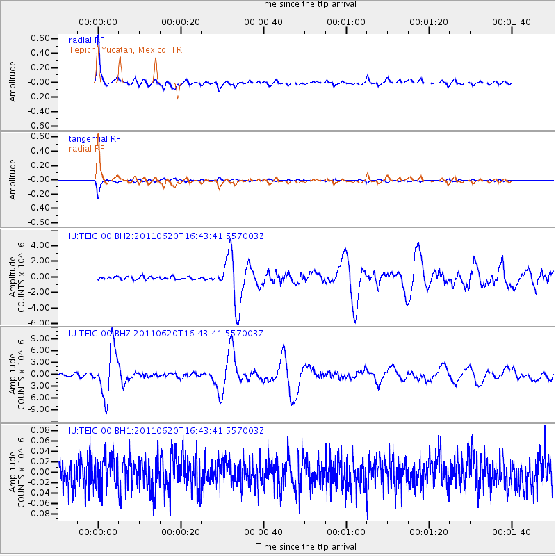
Signal To Noise
| Channel | StoN | STA | LTA |
| IU:TEIG:00:BHZ:20110620T16:43:41.557003Z | 22.07077 | 6.1429323E-6 | 2.7832886E-7 |
| IU:TEIG:00:BH1:20110620T16:43:41.557003Z | 1.2308105 | 2.9308138E-8 | 2.3812063E-8 |
| IU:TEIG:00:BH2:20110620T16:43:41.557003Z | 18.503143 | 3.344246E-6 | 1.8073933E-7 |
| Arrivals |
| Ps | 4.8 SECOND |
| PpPs | 14 SECOND |
| PsPs/PpSs | 19 SECOND |


