You are here: Home > Network List > US - United States National Seismic Network Stations List
> Station JFWS Jewell Farm, Wisconsin, USA > Earthquake Result Viewer
JFWS Jewell Farm, Wisconsin, USA - Earthquake Result Viewer

| Earthquake location: |
Chile-Bolivia Border Region |
| Earthquake latitude/longitude: |
-21.7/-68.2 |
| Earthquake time(UTC): |
2011/06/20 (171) 16:36:01 GMT |
| Earthquake Depth: |
128 km |
| Earthquake Magnitude: |
6.0 MB, 6.5 MW, 6.5 MW |
| Earthquake Catalog/Contributor: |
WHDF/NEIC |
|
| Network: |
US United States National Seismic Network |
| Station: |
JFWS Jewell Farm, Wisconsin, USA |
| Lat/Lon: |
42.91 N/90.25 W |
| Elevation: |
335 m |
|
| Distance: |
67.4 deg |
| Az: |
342.644 deg |
| Baz: |
157.814 deg |
| Ray Param: |
0.056624476 |
| Estimated Moho Depth: |
34.75 km |
| Estimated Crust Vp/Vs: |
1.91 |
| Assumed Crust Vp: |
6.53 km/s |
| Estimated Crust Vs: |
3.424 km/s |
| Estimated Crust Poisson's Ratio: |
0.31 |
|
| Radial Match: |
97.849 % |
| Radial Bump: |
340 |
| Transverse Match: |
94.06761 % |
| Transverse Bump: |
400 |
| SOD ConfigId: |
558545 |
| Insert Time: |
2013-09-18 20:13:39.766 +0000 |
| GWidth: |
2.5 |
| Max Bumps: |
400 |
| Tol: |
0.001 |
|
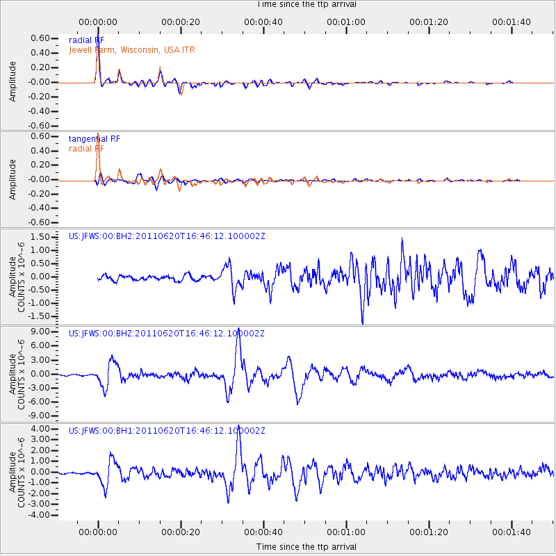
Signal To Noise
| Channel | StoN | STA | LTA |
| US:JFWS:00:BHZ:20110620T16:46:12.100002Z | 27.078285 | 2.669125E-6 | 9.857068E-8 |
| US:JFWS:00:BH1:20110620T16:46:12.100002Z | 14.977238 | 1.1564207E-6 | 7.721188E-8 |
| US:JFWS:00:BH2:20110620T16:46:12.100002Z | 4.8040433 | 4.3545E-7 | 9.06424E-8 |
| Arrivals |
| Ps | 5.0 SECOND |
| PpPs | 15 SECOND |
| PsPs/PpSs | 20 SECOND |


