You are here: Home > Network List > US - United States National Seismic Network Stations List
> Station MVCO Mesa Verde, Colorado, USA > Earthquake Result Viewer
MVCO Mesa Verde, Colorado, USA - Earthquake Result Viewer
| Earthquake location: |
Chile-Bolivia Border Region |
| Earthquake latitude/longitude: |
-21.7/-68.2 |
| Earthquake time(UTC): |
2011/06/20 (171) 16:36:01 GMT |
| Earthquake Depth: |
128 km |
| Earthquake Magnitude: |
6.0 MB, 6.5 MW, 6.5 MW |
| Earthquake Catalog/Contributor: |
WHDF/NEIC |
|
| Network: |
US United States National Seismic Network |
| Station: |
MVCO Mesa Verde, Colorado, USA |
| Lat/Lon: |
37.21 N/108.50 W |
| Elevation: |
2170 m |
|
| Distance: |
69.8 deg |
| Az: |
326.643 deg |
| Baz: |
140.172 deg |
| Ray Param: |
0.05506234 |
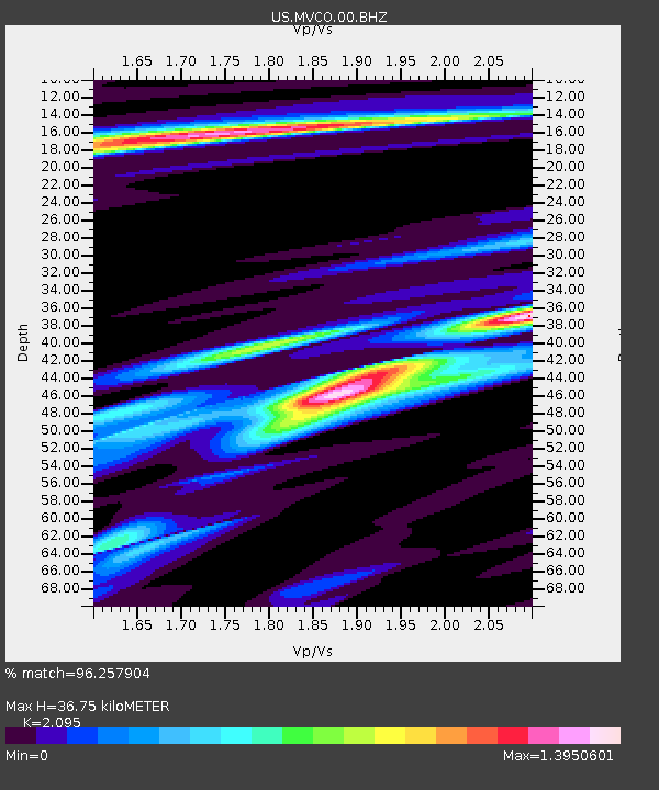
| Estimated Moho Depth: |
36.75 km |
| Estimated Crust Vp/Vs: |
2.10 |
| Assumed Crust Vp: |
6.476 km/s |
| Estimated Crust Vs: |
3.091 km/s |
| Estimated Crust Poisson's Ratio: |
0.35 |
|
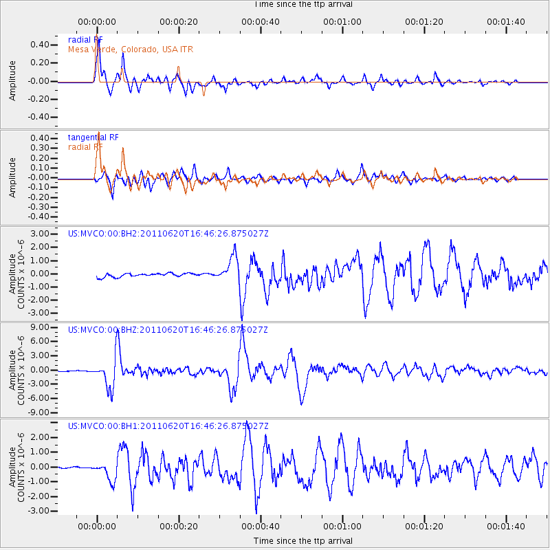
| Radial Match: |
96.257904 % |
| Radial Bump: |
383 |
| Transverse Match: |
90.95909 % |
| Transverse Bump: |
400 |
| SOD ConfigId: |
558545 |
| Insert Time: |
2013-09-18 20:14:03.504 +0000 |
| GWidth: |
2.5 |
| Max Bumps: |
400 |
| Tol: |
0.001 |
|
Signal To Noise
| Channel | StoN | STA | LTA |
| US:MVCO:00:BHZ:20110620T16:46:26.875027Z | 49.678062 | 3.2789849E-6 | 6.600469E-8 |
| US:MVCO:00:BH1:20110620T16:46:26.875027Z | 5.5272255 | 6.23525E-7 | 1.12809765E-7 |
| US:MVCO:00:BH2:20110620T16:46:26.875027Z | 7.308301 | 1.0000757E-6 | 1.3684107E-7 |
| Arrivals |
| Ps | 6.4 SECOND |
| PpPs | 17 SECOND |
| PsPs/PpSs | 23 SECOND |


