You are here: Home > Network List > XD14 - Illuminating the architecture of the greater Mount St. Helens magmatic systems f Stations List
> Station MB07 "Mount St Helens, WA" > Earthquake Result Viewer
MB07 "Mount St Helens, WA" - Earthquake Result Viewer
| Earthquake location: |
Tonga Islands |
| Earthquake latitude/longitude: |
-21.4/-173.3 |
| Earthquake time(UTC): |
2014/09/04 (247) 05:33:46 GMT |
| Earthquake Depth: |
12 km |
| Earthquake Magnitude: |
6.0 MWB |
| Earthquake Catalog/Contributor: |
NEIC PDE/NEIC COMCAT |
|
| Network: |
XD Illuminating the architecture of the greater Mount St. Helens magmatic systems f |
| Station: |
MB07 "Mount St Helens, WA" |
| Lat/Lon: |
46.62 N/122.04 W |
| Elevation: |
878 m |
|
| Distance: |
82.0 deg |
| Az: |
32.858 deg |
| Baz: |
227.189 deg |
| Ray Param: |
0.04720299 |
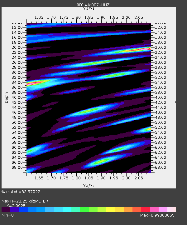
| Estimated Moho Depth: |
20.25 km |
| Estimated Crust Vp/Vs: |
2.09 |
| Assumed Crust Vp: |
6.566 km/s |
| Estimated Crust Vs: |
3.138 km/s |
| Estimated Crust Poisson's Ratio: |
0.35 |
|
| Radial Match: |
83.97022 % |
| Radial Bump: |
400 |
| Transverse Match: |
82.126045 % |
| Transverse Bump: |
400 |
| SOD ConfigId: |
3390531 |
| Insert Time: |
2019-04-13 20:26:19.839 +0000 |
| GWidth: |
2.5 |
| Max Bumps: |
400 |
| Tol: |
0.001 |
|

Signal To Noise
| Channel | StoN | STA | LTA |
| XD:MB07: :HHZ:20140904T05:45:34.875007Z | 10.040706 | 1.6672354E-6 | 1.6604764E-7 |
| XD:MB07: :HHN:20140904T05:45:34.875007Z | 2.654593 | 3.6145508E-7 | 1.3616214E-7 |
| XD:MB07: :HHE:20140904T05:45:34.875007Z | 2.0923357 | 2.8442958E-7 | 1.3593878E-7 |
| Arrivals |
| Ps | 3.4 SECOND |
| PpPs | 9.3 SECOND |
| PsPs/PpSs | 13 SECOND |


