You are here: Home > Network List > US - United States National Seismic Network Stations List
> Station EGMT Eagleton, Montana, USA > Earthquake Result Viewer
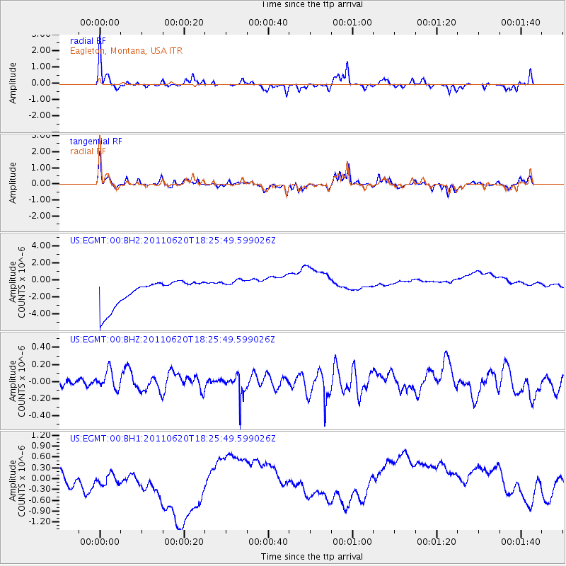
EGMT Eagleton, Montana, USA - Earthquake Result Viewer
*The percent match for this event was below the threshold and hence no stack was calculated.
| Earthquake location: |
Vanuatu Islands |
| Earthquake latitude/longitude: |
-13.3/167.2 |
| Earthquake time(UTC): |
2011/06/20 (171) 18:13:21 GMT |
| Earthquake Depth: |
207 km |
| Earthquake Magnitude: |
5.7 MW |
| Earthquake Catalog/Contributor: |
NEIC PDE/NEIC PDE-M |
|
| Network: |
US United States National Seismic Network |
| Station: |
EGMT Eagleton, Montana, USA |
| Lat/Lon: |
48.02 N/109.75 W |
| Elevation: |
1055 m |
|
| Distance: |
95.2 deg |
| Az: |
41.994 deg |
| Baz: |
256.005 deg |
| Ray Param: |
$rayparam |
*The percent match for this event was below the threshold and hence was not used in the summary stack. |
|
| Radial Match: |
73.39856 % |
| Radial Bump: |
258 |
| Transverse Match: |
68.870346 % |
| Transverse Bump: |
318 |
| SOD ConfigId: |
558545 |
| Insert Time: |
2013-09-18 20:16:02.681 +0000 |
| GWidth: |
2.5 |
| Max Bumps: |
400 |
| Tol: |
0.001 |
|
Signal To Noise
| Channel | StoN | STA | LTA |
| US:EGMT:00:BHZ:20110620T18:25:49.599026Z | 0.80774665 | 2.2005585E-7 | 2.7243178E-7 |
| US:EGMT:00:BH1:20110620T18:25:49.599026Z | 1.0505729 | 8.698216E-7 | 8.2794975E-7 |
| US:EGMT:00:BH2:20110620T18:25:49.599026Z | 0.80283195 | 1.1941648E-6 | 1.4874406E-6 |
| Arrivals |
| Ps | |
| PpPs | |
| PsPs/PpSs | |


