You are here: Home > Network List > XD14 - Illuminating the architecture of the greater Mount St. Helens magmatic systems f Stations List
> Station MH01 "Mount St Helens, WA" > Earthquake Result Viewer
MH01 "Mount St Helens, WA" - Earthquake Result Viewer
| Earthquake location: |
Tonga Islands |
| Earthquake latitude/longitude: |
-21.4/-173.3 |
| Earthquake time(UTC): |
2014/09/04 (247) 05:33:46 GMT |
| Earthquake Depth: |
12 km |
| Earthquake Magnitude: |
6.0 MWB |
| Earthquake Catalog/Contributor: |
NEIC PDE/NEIC COMCAT |
|
| Network: |
XD Illuminating the architecture of the greater Mount St. Helens magmatic systems f |
| Station: |
MH01 "Mount St Helens, WA" |
| Lat/Lon: |
46.26 N/122.81 W |
| Elevation: |
197 m |
|
| Distance: |
81.3 deg |
| Az: |
32.759 deg |
| Baz: |
226.623 deg |
| Ray Param: |
0.047646858 |
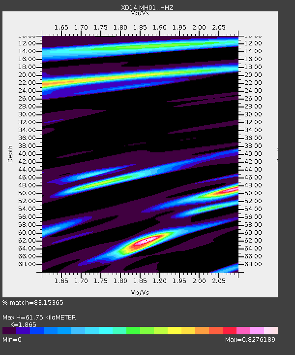
| Estimated Moho Depth: |
61.75 km |
| Estimated Crust Vp/Vs: |
1.87 |
| Assumed Crust Vp: |
6.566 km/s |
| Estimated Crust Vs: |
3.521 km/s |
| Estimated Crust Poisson's Ratio: |
0.30 |
|
| Radial Match: |
83.15365 % |
| Radial Bump: |
400 |
| Transverse Match: |
59.350727 % |
| Transverse Bump: |
400 |
| SOD ConfigId: |
3390531 |
| Insert Time: |
2019-04-13 20:26:33.734 +0000 |
| GWidth: |
2.5 |
| Max Bumps: |
400 |
| Tol: |
0.001 |
|

Signal To Noise
| Channel | StoN | STA | LTA |
| XD:MH01: :HHZ:20140904T05:45:31.560005Z | 7.7552867 | 2.151522E-6 | 2.7742652E-7 |
| XD:MH01: :HHN:20140904T05:45:31.560005Z | 1.1844207 | 3.9607593E-7 | 3.3440477E-7 |
| XD:MH01: :HHE:20140904T05:45:31.560005Z | 1.0401677 | 3.8700355E-7 | 3.7205885E-7 |
| Arrivals |
| Ps | 8.4 SECOND |
| PpPs | 26 SECOND |
| PsPs/PpSs | 35 SECOND |


