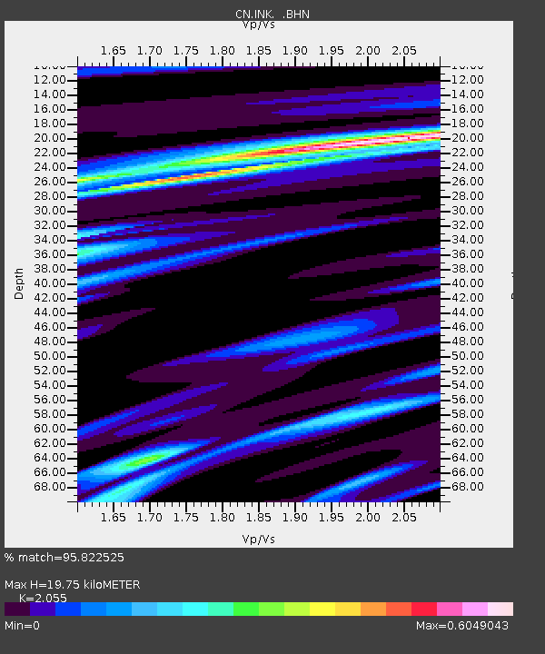
INK INUVIK, NT, CANADA.ANADA - Earthquake Result Viewer
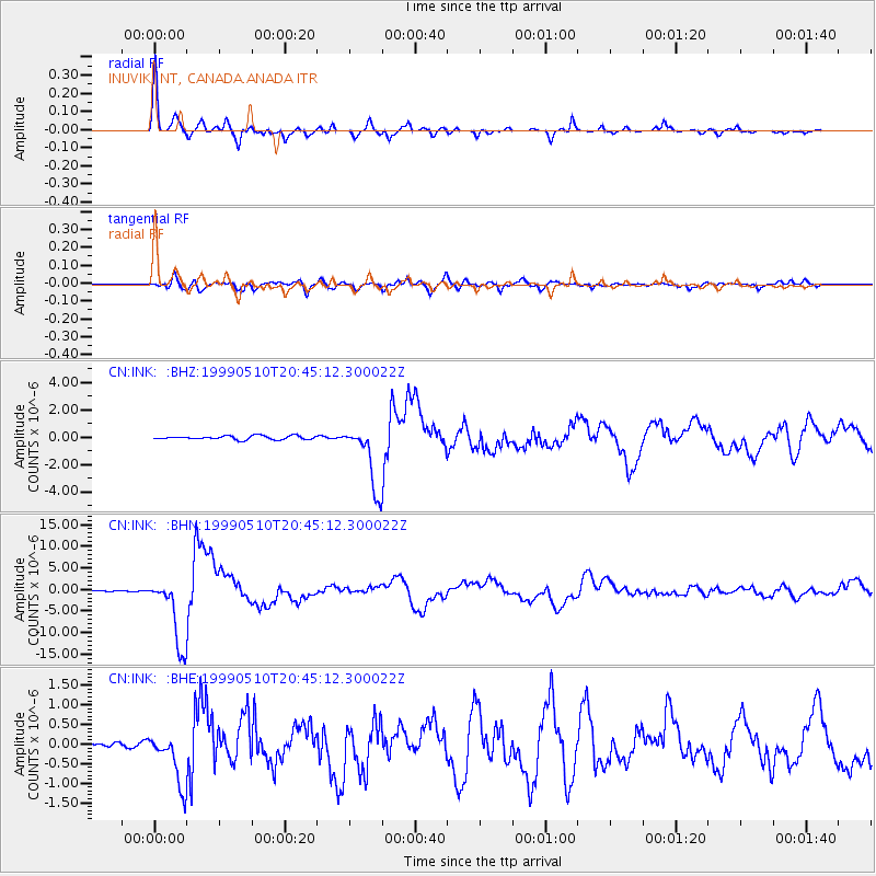
Earthquake location: New Britain Region, P.N.G.
Earthquake latitude/longitude: -5.2/150.9
Earthquake time(UTC): 1999/05/10 (130) 20:33:02 GMT
Earthquake Depth: 138 km
Earthquake Magnitude: 6.5 MB, 6.8 MS, 7.1 MW, 6.5 MB
Earthquake Catalog/Contributor: WHDF/NEIC
Network: CN Canadian National Seismograph Network
Station: INK INUVIK, NT, CANADA.ANADA
Lat/Lon: 68.31 N/133.52 W
Elevation: 40 m
Distance: 89.5 deg
Az: 21.108 deg
Baz: 254.742 deg
Ray Param: 0.041713495
Estimated Moho Depth: 19.75 km
Estimated Crust Vp/Vs: 2.06
Assumed Crust Vp: 6.171 km/s
Estimated Crust Vs: 3.003 km/s
Estimated Crust Poisson's Ratio: 0.34
Radial Match: 95.822525 %
Radial Bump: 363
Transverse Match: 89.02331 %
Transverse Bump: 398
SOD ConfigId: 4480
Insert Time: 2010-02-27 06:05:38.962 +0000
GWidth: 2.5
Max Bumps: 400
Tol: 0.001

Signal To Noise

ChannelStoNSTALTA
CN:INK: :BHN:19990510T20:45:12.300022Z52.1709638.088131E-61.5503127E-7
CN:INK: :BHE:19990510T20:45:12.300022Z8.6120976.804076E-77.900603E-8
CN:INK: :BHZ:19990510T20:45:12.300022Z17.428772.3803868E-61.3657802E-7
Arrivals
Ps3.4 SECOND
PpPs9.6 SECOND
PsPs/PpSs13 SECOND