You are here: Home > Network List > US - United States National Seismic Network Stations List
> Station DUG Dugway, Tooele County, Utah, USA > Earthquake Result Viewer
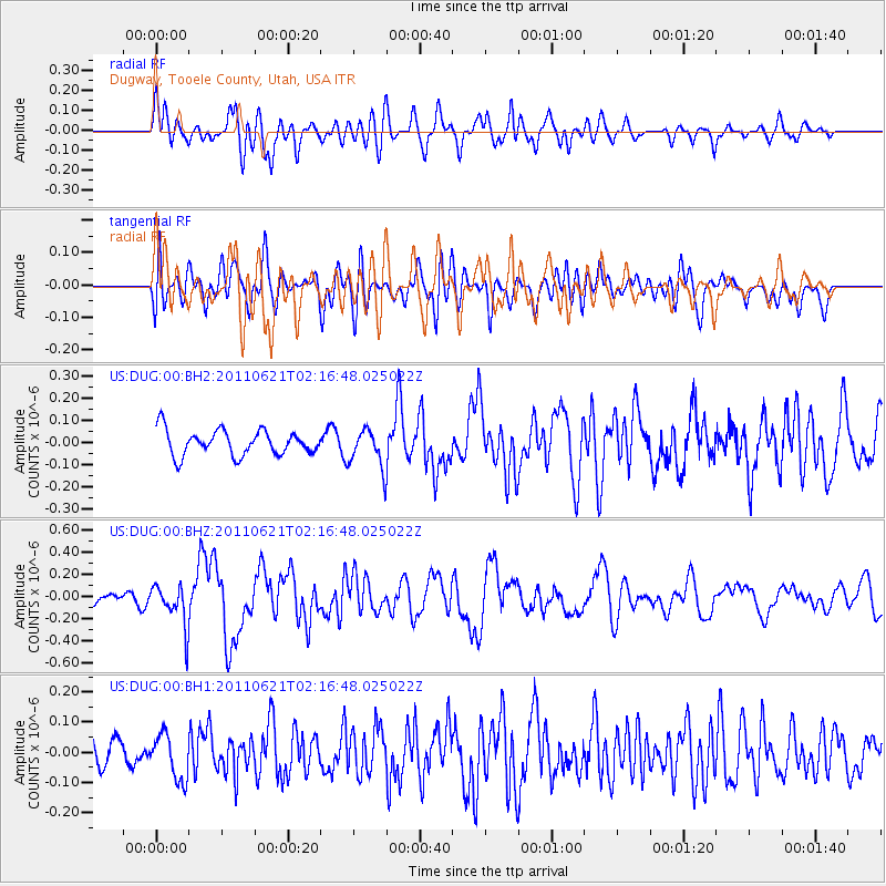
DUG Dugway, Tooele County, Utah, USA - Earthquake Result Viewer
*The percent match for this event was below the threshold and hence no stack was calculated.
| Earthquake location: |
Santa Cruz Islands |
| Earthquake latitude/longitude: |
-11.5/165.6 |
| Earthquake time(UTC): |
2011/06/21 (172) 02:04:15 GMT |
| Earthquake Depth: |
14 km |
| Earthquake Magnitude: |
5.8 MB, 5.8 MS, 6.0 MW, 6.0 MW |
| Earthquake Catalog/Contributor: |
WHDF/NEIC |
|
| Network: |
US United States National Seismic Network |
| Station: |
DUG Dugway, Tooele County, Utah, USA |
| Lat/Lon: |
40.19 N/112.81 W |
| Elevation: |
1477 m |
|
| Distance: |
91.0 deg |
| Az: |
49.284 deg |
| Baz: |
255.927 deg |
| Ray Param: |
$rayparam |
*The percent match for this event was below the threshold and hence was not used in the summary stack. |
|
| Radial Match: |
70.412964 % |
| Radial Bump: |
400 |
| Transverse Match: |
62.05697 % |
| Transverse Bump: |
400 |
| SOD ConfigId: |
558545 |
| Insert Time: |
2013-09-18 20:17:47.612 +0000 |
| GWidth: |
2.5 |
| Max Bumps: |
400 |
| Tol: |
0.001 |
|
Signal To Noise
| Channel | StoN | STA | LTA |
| US:DUG:00:BHZ:20110621T02:16:48.025022Z | 3.192798 | 1.8685243E-7 | 5.85231E-8 |
| US:DUG:00:BH1:20110621T02:16:48.025022Z | 1.3278434 | 7.527192E-8 | 5.6687345E-8 |
| US:DUG:00:BH2:20110621T02:16:48.025022Z | 1.550078 | 8.8251134E-8 | 5.693335E-8 |
| Arrivals |
| Ps | |
| PpPs | |
| PsPs/PpSs | |


