You are here: Home > Network List > XD14 - Illuminating the architecture of the greater Mount St. Helens magmatic systems f Stations List
> Station MI08 "Mount St Helens, WA" > Earthquake Result Viewer
MI08 "Mount St Helens, WA" - Earthquake Result Viewer
| Earthquake location: |
Tonga Islands |
| Earthquake latitude/longitude: |
-21.4/-173.3 |
| Earthquake time(UTC): |
2014/09/04 (247) 05:33:46 GMT |
| Earthquake Depth: |
12 km |
| Earthquake Magnitude: |
6.0 MWB |
| Earthquake Catalog/Contributor: |
NEIC PDE/NEIC COMCAT |
|
| Network: |
XD Illuminating the architecture of the greater Mount St. Helens magmatic systems f |
| Station: |
MI08 "Mount St Helens, WA" |
| Lat/Lon: |
46.25 N/121.97 W |
| Elevation: |
1246 m |
|
| Distance: |
81.8 deg |
| Az: |
33.165 deg |
| Baz: |
227.282 deg |
| Ray Param: |
0.04735532 |
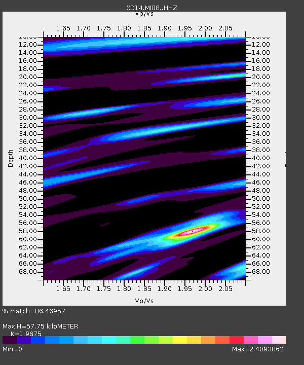
| Estimated Moho Depth: |
57.75 km |
| Estimated Crust Vp/Vs: |
1.97 |
| Assumed Crust Vp: |
6.597 km/s |
| Estimated Crust Vs: |
3.353 km/s |
| Estimated Crust Poisson's Ratio: |
0.33 |
|
| Radial Match: |
86.46957 % |
| Radial Bump: |
400 |
| Transverse Match: |
73.19408 % |
| Transverse Bump: |
400 |
| SOD ConfigId: |
3390531 |
| Insert Time: |
2019-04-13 20:26:41.048 +0000 |
| GWidth: |
2.5 |
| Max Bumps: |
400 |
| Tol: |
0.001 |
|

Signal To Noise
| Channel | StoN | STA | LTA |
| XD:MI08: :HHZ:20140904T05:45:33.729988Z | 9.2269745 | 1.3450198E-6 | 1.457704E-7 |
| XD:MI08: :HHN:20140904T05:45:33.729988Z | 1.3796804 | 3.2984525E-7 | 2.3907367E-7 |
| XD:MI08: :HHE:20140904T05:45:33.729988Z | 1.3179995 | 2.2366484E-7 | 1.6970024E-7 |
| Arrivals |
| Ps | 8.7 SECOND |
| PpPs | 25 SECOND |
| PsPs/PpSs | 34 SECOND |


