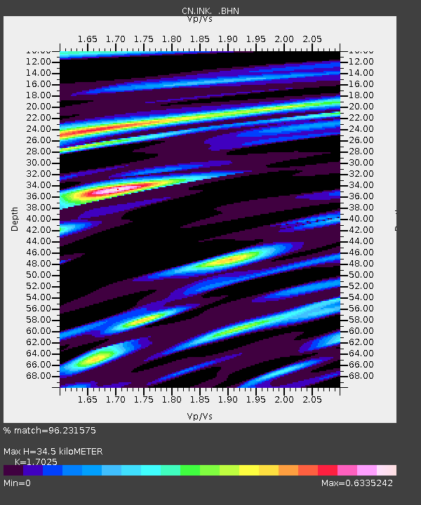
INK INUVIK, NT, CANADA.ANADA - Earthquake Result Viewer
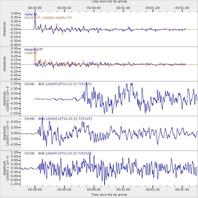
Earthquake location: New Britain Region, P.N.G.
Earthquake latitude/longitude: -4.8/152.5
Earthquake time(UTC): 1999/05/16 (136) 00:51:20 GMT
Earthquake Depth: 74 km
Earthquake Magnitude: 6.0 MB, 7.0 MS, 7.1 MW, 6.3 ME
Earthquake Catalog/Contributor: WHDF/NEIC
Network: CN Canadian National Seismograph Network
Station: INK INUVIK, NT, CANADA.ANADA
Lat/Lon: 68.31 N/133.52 W
Elevation: 40 m
Distance: 88.5 deg
Az: 20.946 deg
Baz: 253.394 deg
Ray Param: 0.042381864
Estimated Moho Depth: 34.5 km
Estimated Crust Vp/Vs: 1.70
Assumed Crust Vp: 6.171 km/s
Estimated Crust Vs: 3.625 km/s
Estimated Crust Poisson's Ratio: 0.24
Radial Match: 96.231575 %
Radial Bump: 310
Transverse Match: 84.012505 %
Transverse Bump: 400
SOD ConfigId: 4480
Insert Time: 2010-02-27 06:05:43.087 +0000
GWidth: 2.5
Max Bumps: 400
Tol: 0.001

Signal To Noise

ChannelStoNSTALTA
CN:INK: :BHN:19990516T01:03:33.725015Z23.5221231.4753127E-66.2720225E-8
CN:INK: :BHE:19990516T01:03:33.725015Z2.91131761.6135259E-75.5422532E-8
CN:INK: :BHZ:19990516T01:03:33.725015Z10.8641434.208141E-73.8734218E-8
Arrivals
Ps4.0 SECOND
PpPs15 SECOND
PsPs/PpSs19 SECOND