You are here: Home > Network List > IU - Global Seismograph Network (GSN - IRIS/USGS) Stations List
> Station MAKZ Makanchi, Kazakhstan > Earthquake Result Viewer
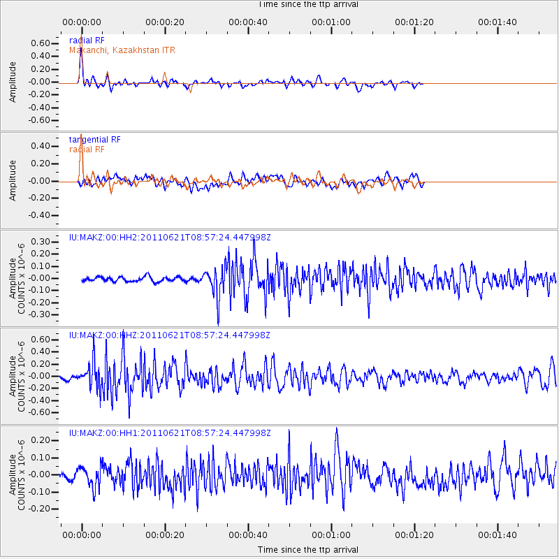
MAKZ Makanchi, Kazakhstan - Earthquake Result Viewer
*The percent match for this event was below the threshold and hence no stack was calculated.
| Earthquake location: |
Near East Coast Of Honshu, Japan |
| Earthquake latitude/longitude: |
35.6/141.3 |
| Earthquake time(UTC): |
2011/06/21 (172) 08:49:40 GMT |
| Earthquake Depth: |
15 km |
| Earthquake Magnitude: |
5.5 MB |
| Earthquake Catalog/Contributor: |
NEIC PDE/NEIC PDE-M |
|
| Network: |
IU Global Seismograph Network (GSN - IRIS/USGS) |
| Station: |
MAKZ Makanchi, Kazakhstan |
| Lat/Lon: |
46.81 N/81.98 E |
| Elevation: |
600 m |
|
| Distance: |
45.0 deg |
| Az: |
303.358 deg |
| Baz: |
82.173 deg |
| Ray Param: |
$rayparam |
*The percent match for this event was below the threshold and hence was not used in the summary stack. |
|
| Radial Match: |
68.99245 % |
| Radial Bump: |
400 |
| Transverse Match: |
52.47485 % |
| Transverse Bump: |
400 |
| SOD ConfigId: |
558545 |
| Insert Time: |
2013-09-18 20:19:13.372 +0000 |
| GWidth: |
2.5 |
| Max Bumps: |
400 |
| Tol: |
0.001 |
|
Signal To Noise
| Channel | StoN | STA | LTA |
| IU:MAKZ:00:HHZ:20110621T08:57:24.447998Z | 5.414016 | 2.1860392E-7 | 4.0377408E-8 |
| IU:MAKZ:00:HH1:20110621T08:57:24.447998Z | 2.3630185 | 6.1988196E-8 | 2.6232632E-8 |
| IU:MAKZ:00:HH2:20110621T08:57:24.447998Z | 6.4081907 | 1.2051446E-7 | 1.8806315E-8 |
| Arrivals |
| Ps | |
| PpPs | |
| PsPs/PpSs | |


