You are here: Home > Network List > US - United States National Seismic Network Stations List
> Station DGMT Dagmar, Montana, USA > Earthquake Result Viewer
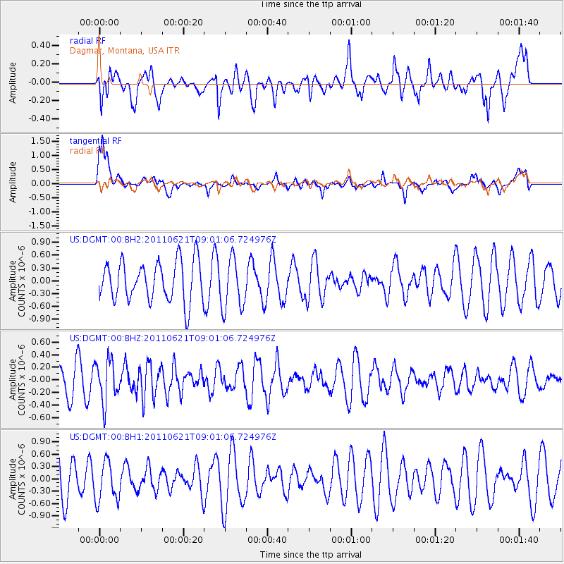
DGMT Dagmar, Montana, USA - Earthquake Result Viewer
*The percent match for this event was below the threshold and hence no stack was calculated.
| Earthquake location: |
Near East Coast Of Honshu, Japan |
| Earthquake latitude/longitude: |
35.6/141.3 |
| Earthquake time(UTC): |
2011/06/21 (172) 08:49:40 GMT |
| Earthquake Depth: |
15 km |
| Earthquake Magnitude: |
5.5 MB |
| Earthquake Catalog/Contributor: |
NEIC PDE/NEIC PDE-M |
|
| Network: |
US United States National Seismic Network |
| Station: |
DGMT Dagmar, Montana, USA |
| Lat/Lon: |
48.47 N/104.20 W |
| Elevation: |
0.0 m |
|
| Distance: |
78.0 deg |
| Az: |
38.256 deg |
| Baz: |
310.712 deg |
| Ray Param: |
$rayparam |
*The percent match for this event was below the threshold and hence was not used in the summary stack. |
|
| Radial Match: |
51.06928 % |
| Radial Bump: |
400 |
| Transverse Match: |
72.004265 % |
| Transverse Bump: |
400 |
| SOD ConfigId: |
558545 |
| Insert Time: |
2013-09-18 20:19:51.041 +0000 |
| GWidth: |
2.5 |
| Max Bumps: |
400 |
| Tol: |
0.001 |
|
Signal To Noise
| Channel | StoN | STA | LTA |
| US:DGMT:00:BHZ:20110621T09:01:06.724976Z | 1.7036866 | 3.3245206E-7 | 1.9513688E-7 |
| US:DGMT:00:BH1:20110621T09:01:06.724976Z | 1.2648449 | 5.000754E-7 | 3.9536496E-7 |
| US:DGMT:00:BH2:20110621T09:01:06.724976Z | 1.311968 | 6.1214814E-7 | 4.665877E-7 |
| Arrivals |
| Ps | |
| PpPs | |
| PsPs/PpSs | |


