You are here: Home > Network List > US - United States National Seismic Network Stations List
> Station WMOK Wichita Mountains, Oklahoma, USA > Earthquake Result Viewer
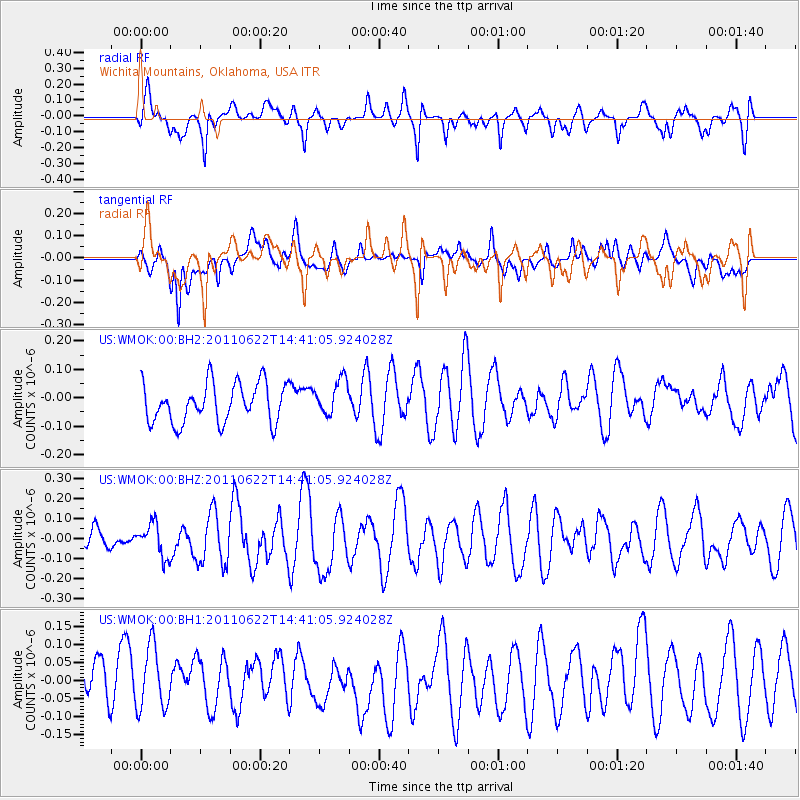
WMOK Wichita Mountains, Oklahoma, USA - Earthquake Result Viewer
*The percent match for this event was below the threshold and hence no stack was calculated.
| Earthquake location: |
Near East Coast Of Honshu, Japan |
| Earthquake latitude/longitude: |
40.0/142.8 |
| Earthquake time(UTC): |
2011/06/22 (173) 14:28:59 GMT |
| Earthquake Depth: |
43 km |
| Earthquake Magnitude: |
5.7 MW |
| Earthquake Catalog/Contributor: |
NEIC PDE/NEIC PDE-M |
|
| Network: |
US United States National Seismic Network |
| Station: |
WMOK Wichita Mountains, Oklahoma, USA |
| Lat/Lon: |
34.74 N/98.78 W |
| Elevation: |
486 m |
|
| Distance: |
86.4 deg |
| Az: |
46.516 deg |
| Baz: |
317.444 deg |
| Ray Param: |
$rayparam |
*The percent match for this event was below the threshold and hence was not used in the summary stack. |
|
| Radial Match: |
52.669918 % |
| Radial Bump: |
400 |
| Transverse Match: |
55.077885 % |
| Transverse Bump: |
400 |
| SOD ConfigId: |
558545 |
| Insert Time: |
2013-09-18 20:23:44.949 +0000 |
| GWidth: |
2.5 |
| Max Bumps: |
400 |
| Tol: |
0.001 |
|
Signal To Noise
| Channel | StoN | STA | LTA |
| US:WMOK:00:BHZ:20110622T14:41:05.924028Z | 1.4731296 | 8.2262815E-8 | 5.584221E-8 |
| US:WMOK:00:BH1:20110622T14:41:05.924028Z | 1.1434083 | 9.179632E-8 | 8.0283066E-8 |
| US:WMOK:00:BH2:20110622T14:41:05.924028Z | 0.92242867 | 6.357301E-8 | 6.8919164E-8 |
| Arrivals |
| Ps | |
| PpPs | |
| PsPs/PpSs | |


