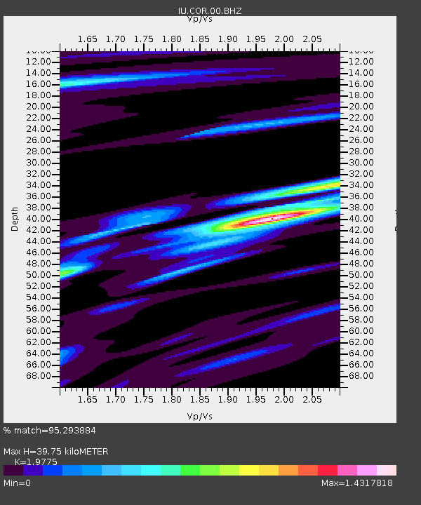
COR Corvallis, Oregon, USA - Earthquake Result Viewer
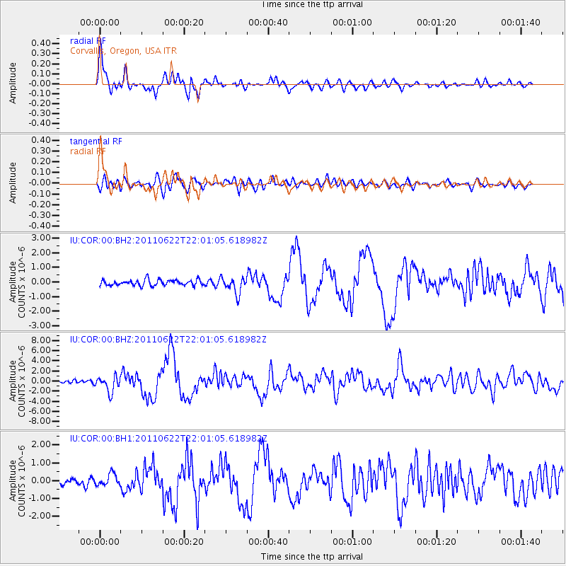
Earthquake location: Near East Coast Of Honshu, Japan
Earthquake latitude/longitude: 40.0/142.2
Earthquake time(UTC): 2011/06/22 (173) 21:50:52 GMT
Earthquake Depth: 33 km
Earthquake Magnitude: 6.7 MW, 6.1 MB, 6.7 MW, 6.7 MS
Earthquake Catalog/Contributor: NEIC PDE/NEIC PDE-M
Network: IU Global Seismograph Network (GSN - IRIS/USGS)
Station: COR Corvallis, Oregon, USA
Lat/Lon: 44.59 N/123.30 W
Elevation: 110 m
Distance: 66.1 deg
Az: 51.162 deg
Baz: 303.08 deg
Ray Param: 0.057758175
Estimated Moho Depth: 39.75 km
Estimated Crust Vp/Vs: 1.98
Assumed Crust Vp: 6.566 km/s
Estimated Crust Vs: 3.32 km/s
Estimated Crust Poisson's Ratio: 0.33
Radial Match: 95.293884 %
Radial Bump: 400
Transverse Match: 82.57128 %
Transverse Bump: 400
SOD ConfigId: 558545
Insert Time: 2013-09-18 20:24:36.433 +0000
GWidth: 2.5
Max Bumps: 400
Tol: 0.001

Signal To Noise

ChannelStoNSTALTA
IU:COR:00:BHZ:20110622T22:01:05.618982Z5.22649771.629416E-63.1176057E-7
IU:COR:00:BH1:20110622T22:01:05.618982Z1.69248253.3374823E-71.971945E-7
IU:COR:00:BH2:20110622T22:01:05.618982Z2.90242725.668652E-71.9530728E-7
Arrivals
Ps6.1 SECOND
PpPs17 SECOND
PsPs/PpSs23 SECOND